Esperanza geodata
Esperanza (Central Visayas) is a populated place; located in Philippines in Asia/Manila (GMT+8) time zone. With population of 5,257 people, there are 1217 cities with bigger population in this country. Compared to other cities in Philippines, 60.9% of cities are located further ↑North; 75.8% of cities are located further ←West and 85.4% of cities have higher elevation than Esperanza. Note1
Administrative division(s):
- Level 1: Central Visayas
- Level 2: Province of Cebu
- Level 3: San Francisco


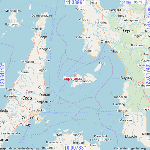
Esperanza GPS coordinates[2]
10° 41' 58.2" North, 124° 18' 51.48" East
| Map corner | latitude | longitude |
|---|---|---|
| Upper-left | 11.3896°, | 123.61118° |
| Center: | 10.6995°, | 124.3143° |
| Lower-right: | 10.00783°, | 125.01743° |
| Map W x H: | 153.6×153.6 km | = 95.4×95.4mi |
| max Lat: | 20.78733° ⇑60.9% North |
| Esperanza: | 10.6995° |
| min Lat: | ⇓39.1% South 4.65442° |
| min Long | Esperanza | max Long |
| 117.04868° | 124.3143° | 126.58417° |
| W 75.8%⇐ | ⇒24.2% E |
Elevation
Elevation of Esperanza is 8 m = 26 ft, and this is 79.9 m = 262 ft below average elevation for this country.
| Max E: |
2262 m = 7421 ft | 85.4% |
| Avg. | 87.9 m = 288 ft | |
| Esperanza | 8 m = 26 ft | |
Min E: |
-2 m = -7 ft | 14.6% |
See also: Philippines elevation on elevation.city.
Geographical zone
Esperanza is located in North Torrid zone (between Equator and Tropic of Cancer). Distance of Equator is 1189.7 km =739.2 mi to South.| Distance of | km | miles | from Esperanza |
|---|---|---|---|
| North Pole | 8817.4 | 5478.9 | to North |
| Arctic Circle | 6211.5 | 3859.6 | to North |
| Tropic Cancer | 1416.2 | 880 | to North |
| Equator | 1189.7 | 739.2 | to South |


Nearby cities:
15 places around Esperanza: (largest is in red/bold)
• Bantiqui
27.3 km =17 mi,  23°
23°
• Bilwang
26.4 km =16.4 mi,  39°
39°
• Consuelo
7.3 km =4.5 mi,  191°
191°
• Esperanza
10.9 km =6.8 mi,  88°
88°
• Himensulan
12 km =7.5 mi,  197°
197°
• Isabel
28.4 km =17.6 mi,  27°
27°
• Libertad
28.3 km =17.6 mi, 31°
• Matlang
26.2 km =16.3 mi, 36°
• Mercedes
10.2 km =6.3 mi,  109°
109°
• Poro
12.9 km =8 mi,  127°
127°
• San Francisco
9.5 km =5.9 mi, 128°
• Santa Cruz
6 km =3.7 mi,  153°
153°
• Santiago
12.2 km =7.6 mi,  183°
183°
• Tudela
18.6 km =11.6 mi, 111°
• Union
3.5 km =2.2 mi,  160°
160°
Sources, notices
• [Note1] Compared only with cities in Philippines existing in our database
• [Src1] Map data: © OpenStreetMap contributors (CC-BY-SA)
• [Src2] Other city data from geonames.org with taken over terms of usage.
• [Src3] Geographical zone / Annual Mean Temperature by Robert A. Rohde @ Wikipedia
