Tubao geodata
Tubao (Northern Mindanao) is a populated place; located in Philippines in Asia/Manila (GMT+8) time zone. With population of 2,965 people, there are 2573 cities with bigger population in this country. Compared to other cities in Philippines, 79.8% of cities are located further ↑North; 68.7% of cities are located further ←West and 99.6% of cities have higher elevation than Tubao. Note1
Administrative division(s):
- Level 1: Northern Mindanao
- Level 2: Province of Misamis Occidental
- Level 3: Jimenez


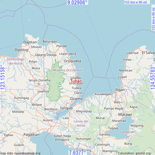
Tubao GPS coordinates[2]
8° 20' 2.4" North, 123° 51' 16.92" East
| Map corner | latitude | longitude |
|---|---|---|
| Upper-left | 9.02906°, | 123.15158° |
| Center: | 8.334°, | 123.8547° |
| Lower-right: | 7.6377°, | 124.55783° |
| Map W x H: | 154.7×154.7 km | = 96.1×96.1mi |
| max Lat: | 20.78733° ⇑79.8% North |
| Tubao: | 8.334° |
| min Lat: | ⇓20.2% South 4.65442° |
| min Long | Tubao | max Long |
| 117.04868° | 123.8547° | 126.58417° |
| W 68.7%⇐ | ⇒31.3% E |
Elevation
Elevation of Tubao is 1 m = 3 ft, and this is 86.9 m = 285 ft below average elevation for this country.
| Max E: |
2262 m = 7421 ft | 99.6% |
| Avg. | 87.9 m = 288 ft | |
| Tubao | 1 m = 3 ft | |
Min E: |
-2 m = -7 ft | 0.4% |
See also: Philippines elevation on elevation.city.
Geographical zone
Tubao is located in North Torrid zone (between Equator and Tropic of Cancer). Distance of Equator is 926.7 km =575.8 mi to South.| Distance of | km | miles | from Tubao |
|---|---|---|---|
| North Pole | 9080.4 | 5642.3 | to North |
| Arctic Circle | 6474.5 | 4023.1 | to North |
| Tropic Cancer | 1679.3 | 1043.5 | to North |
| Equator | 926.7 | 575.8 | to South |


Nearby cities:
15 places around Tubao: (largest is in red/bold)
• Bagakay
21.4 km =13.3 mi,  191°
191°
• Clarin
14.6 km =9.1 mi,  178°
178°
• Esperanza
23.9 km =14.9 mi,  135°
135°
• Jimenez
1.8 km =1.1 mi,  278°
278°
• Langcangan
19.5 km =12.1 mi,  326°
326°
• Lapase
15.8 km =9.8 mi, 176°
• Libertad
6.8 km =4.2 mi,  195°
195°
• Maigo
22.3 km =13.9 mi,  149°
149°
• Oroquieta
17.8 km =11.1 mi,  341°
341°
• Ozamiz City
20.7 km =12.9 mi, 184°
• Pan-an
12.9 km =8 mi, 187°
• Pines
14.1 km =8.8 mi, 338°
• Sinacaban
5.5 km =3.4 mi, 197°
• Sinonoc
2.9 km =1.8 mi, 199°
• Tudela
9.7 km =6 mi, 187°
Sources, notices
• [Note1] Compared only with cities in Philippines existing in our database
• [Src1] Map data: © OpenStreetMap contributors (CC-BY-SA)
• [Src2] Other city data from geonames.org with taken over terms of usage.
• [Src3] Geographical zone / Annual Mean Temperature by Robert A. Rohde @ Wikipedia
