Tinago geodata
Tinago (Bicol) is a populated place; located in Philippines in Asia/Manila (GMT+8) time zone. With population of 4,491 people, there are 1495 cities with bigger population in this country. Compared to other cities in Philippines, 58.8% of cities are located further ↓South; 64.7% of cities are located further ←West and 84.5% of cities have lower elevation than Tinago. Note1


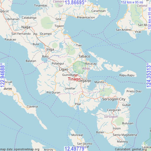
Tinago GPS coordinates[2]
13° 10' 59.988" North, 123° 39' 0" East
| Map corner | latitude | longitude |
|---|---|---|
| Upper-left | 13.86695°, | 122.94688° |
| Center: | 13.18333°, | 123.65° |
| Lower-right: | 12.49779°, | 124.35313° |
| Map W x H: | 152.2×152.2 km | = 94.6×94.6mi |
| max Lat: | 20.78733° ⇑41.2% North |
| Tinago: | 13.18333° |
| min Lat: | ⇓58.8% South 4.65442° |
| min Long | Tinago | max Long |
| 117.04868° | 123.65° | 126.58417° |
| W 64.7%⇐ | ⇒35.3% E |
Elevation
Elevation of Tinago is 130 m = 427 ft, and this is 42.1 m = 138 ft above average elevation for this country.
| Max E: |
2262 m = 7421 ft | 15.5% |
| Tinago | 130 m 427 ft | |
| Avg. | 87.9 m = 288 ft | |
Min E: |
-2 m = -7 ft | 84.5% |
See also: Philippines elevation on elevation.city.
Geographical zone
Tinago is located in North Torrid zone (between Equator and Tropic of Cancer). Distance of this Northern Tropic circle is 1140.1 km =708.4 mi to North.| Distance of | km | miles | from Tinago |
|---|---|---|---|
| North Pole | 8541.2 | 5307.3 | to North |
| Arctic Circle | 5935.3 | 3688 | to North |
| Tropic Cancer | 1140.1 | 708.4 | to North |
| Equator | 1465.8 | 910.8 | to South |


Nearby cities:
15 places around Tinago: (largest is in red/bold)
• Anuling
4 km =2.5 mi,  44°
44°
• Baligang
3.4 km =2.1 mi,  192°
192°
• Cabognon
3 km =1.9 mi,  90°
90°
• Camalig
0.5 km =0.3 mi,  106°
106°
• Cotmon
7.5 km =4.7 mi,  168°
168°
• Daraga
7.8 km =4.8 mi,  119°
119°
• Guinobatan
5.6 km =3.5 mi,  279°
279°
• Lacag
4.6 km =2.9 mi,  132°
132°
• Malabog
4.1 km =2.5 mi, 105°
• Masaraway
6.2 km =3.9 mi,  321°
321°
• Mauraro
7 km =4.3 mi,  237°
237°
• Muladbucad
7.8 km =4.8 mi, 322°
• Pawa
8.7 km =5.4 mi, 94°
• San Rafael
6.6 km =4.1 mi,  304°
304°
• Tagas
7.5 km =4.7 mi,  104°
104°
Sources, notices
• [Note1] Compared only with cities in Philippines existing in our database
• [Src1] Map data: © OpenStreetMap contributors (CC-BY-SA)
• [Src2] Other city data from geonames.org with taken over terms of usage.
• [Src3] Geographical zone / Annual Mean Temperature by Robert A. Rohde @ Wikipedia
