Mauraro geodata
Mauraro (Bicol) is a populated place; located in Philippines in Asia/Manila (GMT+8) time zone. With population of 3,753 people, there are 1878 cities with bigger population in this country. Compared to other cities in Philippines, 58.4% of cities are located further ↓South; 63.8% of cities are located further ←West and 86.6% of cities have lower elevation than Mauraro. Note1


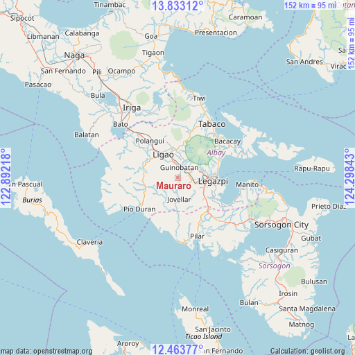
Mauraro GPS coordinates[2]
13° 8' 57.84" North, 123° 35' 43.08" East
| Map corner | latitude | longitude |
|---|---|---|
| Upper-left | 13.83312°, | 122.89218° |
| Center: | 13.1494°, | 123.5953° |
| Lower-right: | 12.46377°, | 124.29843° |
| Map W x H: | 152.3×152.3 km | = 94.6×94.6mi |
| max Lat: | 20.78733° ⇑41.6% North |
| Mauraro: | 13.1494° |
| min Lat: | ⇓58.4% South 4.65442° |
| min Long | Mauraro | max Long |
| 117.04868° | 123.5953° | 126.58417° |
| W 63.8%⇐ | ⇒36.2% E |
Elevation
Elevation of Mauraro is 159 m = 522 ft, and this is 71.1 m = 233 ft above average elevation for this country.
| Max E: |
2262 m = 7421 ft | 13.4% |
| Mauraro | 159 m 522 ft | |
| Avg. | 87.9 m = 288 ft | |
Min E: |
-2 m = -7 ft | 86.6% |
See also: Philippines elevation on elevation.city.
Geographical zone
Mauraro is located in North Torrid zone (between Equator and Tropic of Cancer). Distance of this Northern Tropic circle is 1143.8 km =710.7 mi to North.| Distance of | km | miles | from Mauraro |
|---|---|---|---|
| North Pole | 8545 | 5309.6 | to North |
| Arctic Circle | 5939.1 | 3690.4 | to North |
| Tropic Cancer | 1143.8 | 710.7 | to North |
| Equator | 1462.1 | 908.5 | to South |


Nearby cities:
15 places around Mauraro: (largest is in red/bold)
• Anuling
11 km =6.8 mi,  52°
52°
• Baligang
5.2 km =3.2 mi,  84°
84°
• Bonga
8.9 km =5.5 mi,  326°
326°
• Cabognon
9.7 km =6 mi,  67°
67°
• Camalig
7.4 km =4.6 mi,  60°
60°
• Cotmon
8.2 km =5.1 mi,  115°
115°
• Guinobatan
4.7 km =2.9 mi,  4°
4°
• Jovellar
8.9 km =5.5 mi,  176°
176°
• Lacag
9.3 km =5.8 mi,  85°
85°
• Malabog
10.2 km =6.3 mi, 74°
• Masaraway
8.9 km =5.5 mi,  13°
13°
• Muladbucad
10 km =6.2 mi, 6°
• Salvacion
9.5 km =5.9 mi,  165°
165°
• San Rafael
7.5 km =4.7 mi, 3°
• Tinago
7 km =4.3 mi, 57°
Sources, notices
• [Note1] Compared only with cities in Philippines existing in our database
• [Src1] Map data: © OpenStreetMap contributors (CC-BY-SA)
• [Src2] Other city data from geonames.org with taken over terms of usage.
• [Src3] Geographical zone / Annual Mean Temperature by Robert A. Rohde @ Wikipedia
