Cotmon geodata
Cotmon (Bicol) is a populated place; located in Philippines in Asia/Manila (GMT+8) time zone. With population of 2,770 people, there are 2842 cities with bigger population in this country. Compared to other cities in Philippines, 58.2% of cities are located further ↓South; 64.9% of cities are located further ←West and 80.1% of cities have lower elevation than Cotmon. Note1


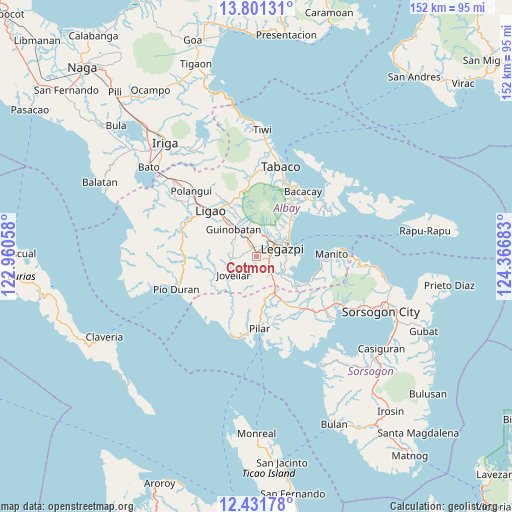
Cotmon GPS coordinates[2]
13° 7' 3" North, 123° 39' 49.32" East
| Map corner | latitude | longitude |
|---|---|---|
| Upper-left | 13.80131°, | 122.96058° |
| Center: | 13.1175°, | 123.6637° |
| Lower-right: | 12.43178°, | 124.36683° |
| Map W x H: | 152.3×152.3 km | = 94.6×94.6mi |
| max Lat: | 20.78733° ⇑41.8% North |
| Cotmon: | 13.1175° |
| min Lat: | ⇓58.2% South 4.65442° |
| min Long | Cotmon | max Long |
| 117.04868° | 123.6637° | 126.58417° |
| W 64.9%⇐ | ⇒35.1% E |
Elevation
Elevation of Cotmon is 93 m = 305 ft, and this is 5.1 m = 17 ft above average elevation for this country.
| Max E: |
2262 m = 7421 ft | 19.9% |
| Cotmon | 93 m 305 ft | |
| Avg. | 87.9 m = 288 ft | |
Min E: |
-2 m = -7 ft | 80.1% |
See also: Philippines elevation on elevation.city.
Geographical zone
Cotmon is located in North Torrid zone (between Equator and Tropic of Cancer). Distance of this Northern Tropic circle is 1147.4 km =713 mi to North.| Distance of | km | miles | from Cotmon |
|---|---|---|---|
| North Pole | 8548.5 | 5311.8 | to North |
| Arctic Circle | 5942.6 | 3692.6 | to North |
| Tropic Cancer | 1147.4 | 713 | to North |
| Equator | 1458.5 | 906.3 | to South |


Nearby cities:
15 places around Cotmon: (largest is in red/bold)
• Aanislag
6.4 km =4 mi,  138°
138°
• Baligang
4.6 km =2.9 mi,  331°
331°
• Barayong
6.1 km =3.8 mi,  108°
108°
• Bariw
7.7 km =4.8 mi,  76°
76°
• Bascaron
4.2 km =2.6 mi, 112°
• Cabognon
7.4 km =4.6 mi,  11°
11°
• Camalig
7.3 km =4.5 mi,  351°
351°
• Daraga
6.3 km =3.9 mi,  56°
56°
• Lacag
4.6 km =2.9 mi,  24°
24°
• Malabog
6.7 km =4.2 mi, 21°
• Mauraro
8.2 km =5.1 mi,  295°
295°
• Sagpon
8.4 km =5.2 mi, 64°
• Salvacion
7.6 km =4.7 mi,  222°
222°
• Tagas
7.9 km =4.9 mi,  46°
46°
• Tinago
7.5 km =4.7 mi, 348°
Sources, notices
• [Note1] Compared only with cities in Philippines existing in our database
• [Src1] Map data: © OpenStreetMap contributors (CC-BY-SA)
• [Src2] Other city data from geonames.org with taken over terms of usage.
• [Src3] Geographical zone / Annual Mean Temperature by Robert A. Rohde @ Wikipedia
