Tigtabon geodata
Tigtabon (Zamboanga Peninsula) is a populated place; located in Philippines in Asia/Manila (GMT+8) time zone. With population of 3,546 people, there are 2024 cities with bigger population in this country. Compared to other cities in Philippines, 92.7% of cities are located further ↑North; 58.3% of cities are located further →East and 92.7% of cities have higher elevation than Tigtabon. Note1
Administrative division(s):
- Level 1: Zamboanga Peninsula
- Level 2: Province of Zamboanga del Sur
- Level 3: Zamboanga City


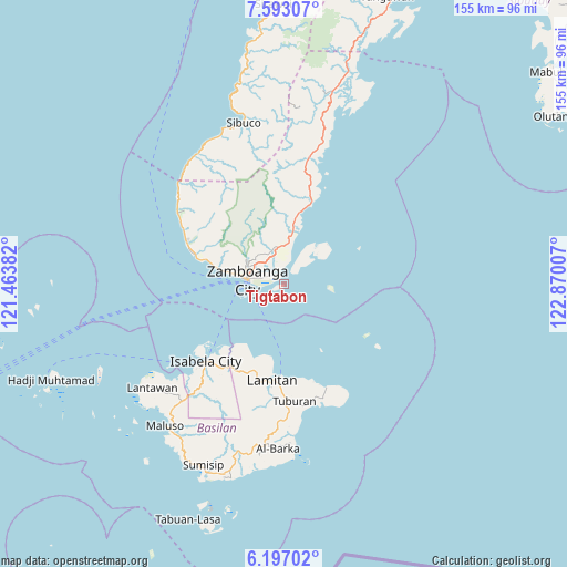
Tigtabon GPS coordinates[2]
6° 53' 44.016" North, 122° 10' 0.984" East
| Map corner | latitude | longitude |
|---|---|---|
| Upper-left | 7.59307°, | 121.46382° |
| Center: | 6.89556°, | 122.16694° |
| Lower-right: | 6.19702°, | 122.87007° |
| Map W x H: | 155.2×155.2 km | = 96.4×96.4mi |
| max Lat: | 20.78733° ⇑92.7% North |
| Tigtabon: | 6.89556° |
| min Lat: | ⇓7.3% South 4.65442° |
| min Long | Tigtabon | max Long |
| 117.04868° | 122.16694° | 126.58417° |
| W 41.7%⇐ | ⇒58.3% E |
Elevation
Elevation of Tigtabon is 6 m = 20 ft, and this is 81.9 m = 269 ft below average elevation for this country.
| Max E: |
2262 m = 7421 ft | 92.7% |
| Avg. | 87.9 m = 288 ft | |
| Tigtabon | 6 m = 20 ft | |
Min E: |
-2 m = -7 ft | 7.3% |
See also: Philippines elevation on elevation.city.
Geographical zone
Tigtabon is located in North Torrid zone (between Equator and Tropic of Cancer). Distance of Equator is 766.7 km =476.4 mi to South.| Distance of | km | miles | from Tigtabon |
|---|---|---|---|
| North Pole | 9240.3 | 5741.7 | to North |
| Arctic Circle | 6634.5 | 4122.5 | to North |
| Tropic Cancer | 1839.2 | 1142.8 | to North |
| Equator | 766.7 | 476.4 | to South |


Nearby cities:
15 places around Tigtabon: (largest is in red/bold)
• Balas
23.4 km =14.5 mi,  187°
187°
• Bunguiao
23.5 km =14.6 mi,  7°
7°
• Cabaluay
11.9 km =7.4 mi, 7°
• Culianan
9.7 km =6 mi,  346°
346°
• Lamisahan
19.5 km =12.1 mi,  357°
357°
• Landang Laum
12.2 km =7.6 mi,  48°
48°
• Lumbayan
6.4 km =4 mi,  333°
333°
• Manicahan
14.3 km =8.9 mi,  15°
15°
• Mercedes
7.3 km =4.5 mi,  343°
343°
• Recodo
23.3 km =14.5 mi,  285°
285°
• Sangali
19.7 km =12.2 mi, 11°
• Talabaan
5.1 km =3.2 mi, 6°
• Taluksangay
6.8 km =4.2 mi, 16°
• Tolosa
15.2 km =9.4 mi, 357°
• Zamboanga
10.4 km =6.5 mi,  279°
279°
Sources, notices
• [Note1] Compared only with cities in Philippines existing in our database
• [Src1] Map data: © OpenStreetMap contributors (CC-BY-SA)
• [Src2] Other city data from geonames.org with taken over terms of usage.
• [Src3] Geographical zone / Annual Mean Temperature by Robert A. Rohde @ Wikipedia
