Platagata geodata
Platagata (Western Visayas) is a populated place; located in Philippines in Asia/Manila (GMT+8) time zone. With population of 2,504 people, there are 3275 cities with bigger population in this country. Compared to other cities in Philippines, 53.2% of cities are located further ↑North; 56% of cities are located further ←West and 95.5% of cities have higher elevation than Platagata. Note1
Administrative division(s):
- Level 1: Western Visayas
- Level 2: Province of Iloilo
- Level 3: Concepcion


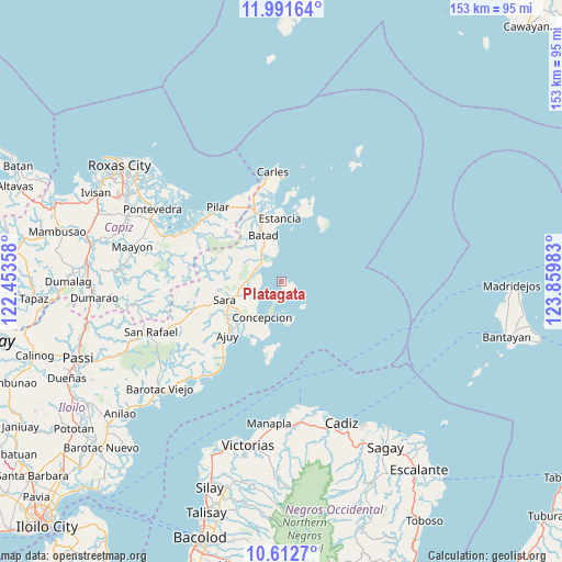
Platagata GPS coordinates[2]
11° 18' 10.8" North, 123° 9' 24.12" East
| Map corner | latitude | longitude |
|---|---|---|
| Upper-left | 11.99164°, | 122.45358° |
| Center: | 11.303°, | 123.1567° |
| Lower-right: | 10.6127°, | 123.85983° |
| Map W x H: | 153.3×153.3 km | = 95.3×95.3mi |
| max Lat: | 20.78733° ⇑53.2% North |
| Platagata: | 11.303° |
| min Lat: | ⇓46.8% South 4.65442° |
| min Long | Platagata | max Long |
| 117.04868° | 123.1567° | 126.58417° |
| W 56%⇐ | ⇒44% E |
Elevation
Elevation of Platagata is 5 m = 16 ft, and this is 82.9 m = 272 ft below average elevation for this country.
| Max E: |
2262 m = 7421 ft | 95.5% |
| Avg. | 87.9 m = 288 ft | |
| Platagata | 5 m = 16 ft | |
Min E: |
-2 m = -7 ft | 4.5% |
See also: Philippines elevation on elevation.city.
Geographical zone
Platagata is located in North Torrid zone (between Equator and Tropic of Cancer). Distance of Equator is 1256.8 km =780.9 mi to South.| Distance of | km | miles | from Platagata |
|---|---|---|---|
| North Pole | 8750.3 | 5437.2 | to North |
| Arctic Circle | 6144.4 | 3818 | to North |
| Tropic Cancer | 1349.1 | 838.3 | to North |
| Equator | 1256.8 | 780.9 | to South |


Nearby cities:
15 places around Platagata: (largest is in red/bold)
• Anoring
14.7 km =9.1 mi,  246°
246°
• Balasan
20.3 km =12.6 mi,  338°
338°
• Batad
13.8 km =8.6 mi, 337°
• Bayas
14.8 km =9.2 mi,  10°
10°
• Binon-an
10.3 km =6.4 mi,  351°
351°
• Concepcion
11.1 km =6.9 mi,  209°
209°
• Estancia
16.9 km =10.5 mi,  358°
358°
• Igbon
9.9 km =6.2 mi,  174°
174°
• Malangabang
9.1 km =5.7 mi,  143°
143°
• Polopina
10.7 km =6.6 mi, 174°
• Quipot
17.2 km =10.7 mi,  262°
262°
• San Dionisio
7.5 km =4.7 mi,  241°
241°
• San Fernando
20.1 km =12.5 mi,  30°
30°
• Sara
16.4 km =10.2 mi, 252°
• Tambalisa
3.8 km =2.4 mi, 166°
Sources, notices
• [Note1] Compared only with cities in Philippines existing in our database
• [Src1] Map data: © OpenStreetMap contributors (CC-BY-SA)
• [Src2] Other city data from geonames.org with taken over terms of usage.
• [Src3] Geographical zone / Annual Mean Temperature by Robert A. Rohde @ Wikipedia
