Polopina geodata
Polopina (Western Visayas) is a populated place; located in Philippines in Asia/Manila (GMT+8) time zone. With population of 3,098 people, there are 2418 cities with bigger population in this country. Compared to other cities in Philippines, 54.4% of cities are located further ↑North; 56.2% of cities are located further ←West and 80.4% of cities have lower elevation than Polopina. Note1
Administrative division(s):
- Level 1: Western Visayas
- Level 2: Province of Iloilo
- Level 3: Concepcion


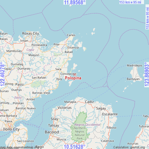
Polopina GPS coordinates[2]
11° 12' 24.48" North, 123° 9' 57.24" East
| Map corner | latitude | longitude |
|---|---|---|
| Upper-left | 11.89568°, | 122.46278° |
| Center: | 11.2068°, | 123.1659° |
| Lower-right: | 10.51628°, | 123.86903° |
| Map W x H: | 153.4×153.4 km | = 95.3×95.3mi |
| max Lat: | 20.78733° ⇑54.4% North |
| Polopina: | 11.2068° |
| min Lat: | ⇓45.6% South 4.65442° |
| min Long | Polopina | max Long |
| 117.04868° | 123.1659° | 126.58417° |
| W 56.2%⇐ | ⇒43.8% E |
Elevation
Elevation of Polopina is 94 m = 308 ft, and this is 6.1 m = 20 ft above average elevation for this country.
| Max E: |
2262 m = 7421 ft | 19.6% |
| Polopina | 94 m 308 ft | |
| Avg. | 87.9 m = 288 ft | |
Min E: |
-2 m = -7 ft | 80.4% |
See also: Philippines elevation on elevation.city.
Geographical zone
Polopina is located in North Torrid zone (between Equator and Tropic of Cancer). Distance of Equator is 1246.1 km =774.3 mi to South.| Distance of | km | miles | from Polopina |
|---|---|---|---|
| North Pole | 8761 | 5443.8 | to North |
| Arctic Circle | 6155.1 | 3824.6 | to North |
| Tropic Cancer | 1359.8 | 844.9 | to North |
| Equator | 1246.1 | 774.3 | to South |


Nearby cities:
15 places around Polopina: (largest is in red/bold)
• Ajuy
16.4 km =10.2 mi,  256°
256°
• Anoring
15.2 km =9.4 mi,  288°
288°
• Batad
24.3 km =15.1 mi,  344°
344°
• Binon-an
21 km =13 mi,  353°
353°
• Concepcion
6.5 km =4 mi,  279°
279°
• Culasi
24.6 km =15.3 mi,  234°
234°
• Igbon
0.8 km =0.5 mi,  356°
356°
• Malangabang
5.5 km =3.4 mi,  52°
52°
• Malayo-an
21 km =13 mi, 234°
• Pili
19.1 km =11.9 mi,  239°
239°
• Platagata
10.7 km =6.6 mi, 354°
• Quipot
20 km =12.4 mi,  295°
295°
• San Dionisio
10.4 km =6.5 mi,  313°
313°
• Sara
17.5 km =10.9 mi, 288°
• Tambalisa
7 km =4.3 mi, 359°
Sources, notices
• [Note1] Compared only with cities in Philippines existing in our database
• [Src1] Map data: © OpenStreetMap contributors (CC-BY-SA)
• [Src2] Other city data from geonames.org with taken over terms of usage.
• [Src3] Geographical zone / Annual Mean Temperature by Robert A. Rohde @ Wikipedia
