Bayas geodata
Bayas (Western Visayas) is a populated place; located in Philippines in Asia/Manila (GMT+8) time zone. With population of 2,275 people, there are 3735 cities with bigger population in this country. Compared to other cities in Philippines, 52.1% of cities are located further ↑North; 56.5% of cities are located further ←West and 92.7% of cities have higher elevation than Bayas. Note1


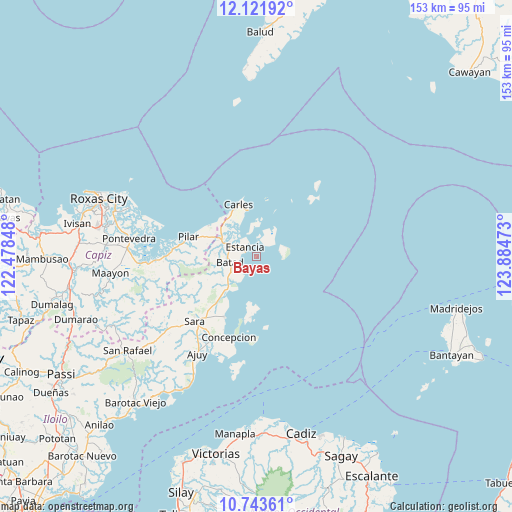
Bayas GPS coordinates[2]
11° 26' 0.96" North, 123° 10' 53.76" East
| Map corner | latitude | longitude |
|---|---|---|
| Upper-left | 12.12192°, | 122.47848° |
| Center: | 11.4336°, | 123.1816° |
| Lower-right: | 10.74361°, | 123.88473° |
| Map W x H: | 153.3×153.3 km | = 95.3×95.3mi |
| max Lat: | 20.78733° ⇑52.1% North |
| Bayas: | 11.4336° |
| min Lat: | ⇓47.9% South 4.65442° |
| min Long | Bayas | max Long |
| 117.04868° | 123.1816° | 126.58417° |
| W 56.5%⇐ | ⇒43.5% E |
Elevation
Elevation of Bayas is 6 m = 20 ft, and this is 81.9 m = 269 ft below average elevation for this country.
| Max E: |
2262 m = 7421 ft | 92.7% |
| Avg. | 87.9 m = 288 ft | |
| Bayas | 6 m = 20 ft | |
Min E: |
-2 m = -7 ft | 7.3% |
See also: Philippines elevation on elevation.city.
Geographical zone
Bayas is located in North Torrid zone (between Equator and Tropic of Cancer). Distance of Equator is 1271.3 km =789.9 mi to South.| Distance of | km | miles | from Bayas |
|---|---|---|---|
| North Pole | 8735.8 | 5428.2 | to North |
| Arctic Circle | 6129.9 | 3808.9 | to North |
| Tropic Cancer | 1334.6 | 829.3 | to North |
| Equator | 1271.3 | 789.9 | to South |


Nearby cities:
15 places around Bayas: (largest is in red/bold)
• Balasan
11.1 km =6.9 mi,  293°
293°
• Bancal
14.2 km =8.8 mi,  348°
348°
• Batad
8.2 km =5.1 mi,  257°
257°
• Binon-an
6.1 km =3.8 mi,  224°
224°
• Cabilao
12.5 km =7.8 mi,  340°
340°
• Carles
16.3 km =10.1 mi, 341°
• Cassanayan
17 km =10.6 mi,  303°
303°
• Estancia
4 km =2.5 mi,  306°
306°
• Guinticgan
15.8 km =9.8 mi, 336°
• Pilar
21 km =13 mi, 286°
• Platagata
14.8 km =9.2 mi,  190°
190°
• San Dionisio
20.3 km =12.6 mi,  207°
207°
• San Fernando
7.9 km =4.9 mi,  69°
69°
• Tambalisa
18.3 km =11.4 mi, 185°
• Tarong
12.1 km =7.5 mi,  333°
333°
Sources, notices
• [Note1] Compared only with cities in Philippines existing in our database
• [Src1] Map data: © OpenStreetMap contributors (CC-BY-SA)
• [Src2] Other city data from geonames.org with taken over terms of usage.
• [Src3] Geographical zone / Annual Mean Temperature by Robert A. Rohde @ Wikipedia
