Sara geodata
Sara (Western Visayas) is a seat of a third-order administrative division; located in Philippines in Asia/Manila (GMT+8) time zone. With population of 4,062 people, there are 1687 cities with bigger population in this country. Compared to other cities in Philippines, 53.7% of cities are located further ↑North; 53.4% of cities are located further ←West and 56.6% of cities have lower elevation than Sara. Note1


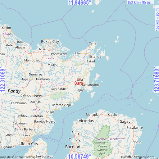
Sara GPS coordinates[2]
11° 15' 28.44" North, 123° 0' 49.68" East
| Map corner | latitude | longitude |
|---|---|---|
| Upper-left | 11.94665°, | 122.31068° |
| Center: | 11.2579°, | 123.0138° |
| Lower-right: | 10.56749°, | 123.71693° |
| Map W x H: | 153.3×153.4 km | = 95.3×95.3mi |
| max Lat: | 20.78733° ⇑53.7% North |
| Sara: | 11.2579° |
| min Lat: | ⇓46.3% South 4.65442° |
| min Long | Sara | max Long |
| 117.04868° | 123.0138° | 126.58417° |
| W 53.4%⇐ | ⇒46.6% E |
Elevation
Elevation of Sara is 29 m = 95 ft, and this is 58.9 m = 193 ft below average elevation for this country.
| Max E: |
2262 m = 7421 ft | 43.4% |
| Avg. | 87.9 m = 288 ft | |
| Sara | 29 m = 95 ft | |
Min E: |
-2 m = -7 ft | 56.6% |
See also: Philippines elevation on elevation.city.
Geographical zone
Sara is located in North Torrid zone (between Equator and Tropic of Cancer). Distance of Equator is 1251.8 km =777.8 mi to South.| Distance of | km | miles | from Sara |
|---|---|---|---|
| North Pole | 8755.3 | 5440.3 | to North |
| Arctic Circle | 6149.4 | 3821.1 | to North |
| Tropic Cancer | 1354.2 | 841.5 | to North |
| Equator | 1251.8 | 777.8 | to South |


Nearby cities:
15 places around Sara: (largest is in red/bold)
• Ajuy
9.5 km =5.9 mi,  176°
176°
• Anoring
2.3 km =1.4 mi,  112°
112°
• Batad
20.6 km =12.8 mi,  29°
29°
• Concepcion
11.2 km =7 mi, 114°
• Culasi
20.2 km =12.6 mi,  189°
189°
• Igbon
17.2 km =10.7 mi, 106°
• Lantangan
19.7 km =12.2 mi,  316°
316°
• Lemery
10.1 km =6.3 mi,  249°
249°
• Malayo-an
17.8 km =11.1 mi, 181°
• Pili
15.4 km =9.6 mi, 179°
• Platagata
16.4 km =10.2 mi,  72°
72°
• Polopina
17.5 km =10.9 mi, 108°
• Quipot
3.2 km =2 mi,  331°
331°
• San Dionisio
9.1 km =5.7 mi,  80°
80°
• Tambalisa
16.5 km =10.3 mi,  85°
85°
Sources, notices
• [Note1] Compared only with cities in Philippines existing in our database
• [Src1] Map data: © OpenStreetMap contributors (CC-BY-SA)
• [Src2] Other city data from geonames.org with taken over terms of usage.
• [Src3] Geographical zone / Annual Mean Temperature by Robert A. Rohde @ Wikipedia
