Tabon geodata
Tabon (Mimaropa) is a populated place; located in Philippines in Asia/Manila (GMT+8) time zone. With population of 3,801 people, there are 1842 cities with bigger population in this country. Compared to other cities in Philippines, 74.4% of cities are located further ↑North; 99.6% of cities are located further →East and 89.7% of cities have higher elevation than Tabon. Note1


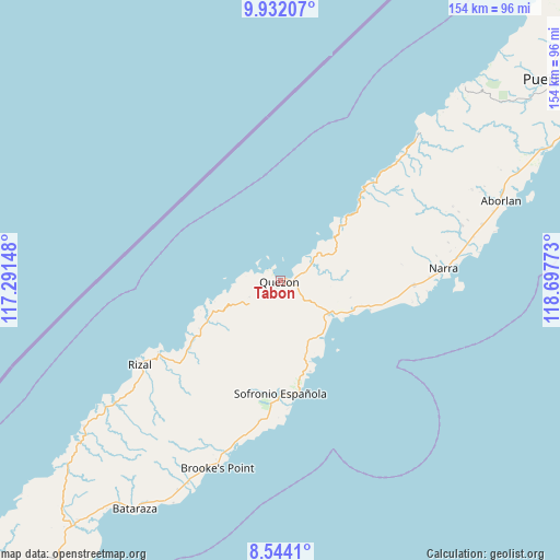
Tabon GPS coordinates[2]
9° 14' 19.572" North, 117° 59' 40.56" East
| Map corner | latitude | longitude |
|---|---|---|
| Upper-left | 9.93207°, | 117.29148° |
| Center: | 9.23877°, | 117.9946° |
| Lower-right: | 8.5441°, | 118.69773° |
| Map W x H: | 154.3×154.3 km | = 95.9×95.9mi |
| max Lat: | 20.78733° ⇑74.4% North |
| Tabon: | 9.23877° |
| min Lat: | ⇓25.6% South 4.65442° |
| min Long | Tabon | max Long |
| 117.04868° | 117.9946° | 126.58417° |
| W 0.4%⇐ | ⇒99.6% E |
Elevation
Elevation of Tabon is 7 m = 23 ft, and this is 80.9 m = 265 ft below average elevation for this country.
| Max E: |
2262 m = 7421 ft | 89.7% |
| Avg. | 87.9 m = 288 ft | |
| Tabon | 7 m = 23 ft | |
Min E: |
-2 m = -7 ft | 10.3% |
See also: Philippines elevation on elevation.city.
Geographical zone
Tabon is located in North Torrid zone (between Equator and Tropic of Cancer). Distance of Equator is 1027.3 km =638.3 mi to South.| Distance of | km | miles | from Tabon |
|---|---|---|---|
| North Pole | 8979.8 | 5579.8 | to North |
| Arctic Circle | 6373.9 | 3960.6 | to North |
| Tropic Cancer | 1578.7 | 981 | to North |
| Equator | 1027.3 | 638.3 | to South |


Nearby cities:
15 places around Tabon: (largest is in red/bold)
• Aramawayan
21.7 km =13.5 mi,  57°
57°
• Aramayuan
22.5 km =14 mi,  109°
109°
• Barong Barong
44.2 km =27.5 mi,  194°
194°
• Bunog
25.8 km =16 mi,  244°
244°
• Burirao
12.3 km =7.6 mi, 110°
• Calatugas
26.3 km =16.3 mi, 107°
• Eraan
37.6 km =23.4 mi, 238°
• Iraray
28 km =17.4 mi,  167°
167°
• Isugod
17.8 km =11.1 mi,  50°
50°
• Labog
21.2 km =13.2 mi,  163°
163°
• Narra
45.1 km =28 mi,  85°
85°
• Panitian
18.8 km =11.7 mi,  147°
147°
• Punang
25.4 km =15.8 mi, 166°
• Quezon
4 km =2.5 mi, 86°
• Tagusao
20.5 km =12.7 mi,  255°
255°
Sources, notices
• [Note1] Compared only with cities in Philippines existing in our database
• [Src1] Map data: © OpenStreetMap contributors (CC-BY-SA)
• [Src2] Other city data from geonames.org with taken over terms of usage.
• [Src3] Geographical zone / Annual Mean Temperature by Robert A. Rohde @ Wikipedia
