Barong Barong geodata
Barong Barong (Mimaropa) is a populated place; located in Philippines in Asia/Manila (GMT+8) time zone. With population of 3,604 people, there are 1977 cities with bigger population in this country. Compared to other cities in Philippines, 76.7% of cities are located further ↑North; 99.7% of cities are located further →East and 53.1% of cities have higher elevation than Barong Barong. Note1


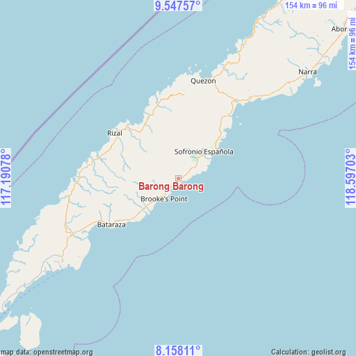
Barong Barong GPS coordinates[2]
8° 51' 12.6" North, 117° 53' 38.04" East
| Map corner | latitude | longitude |
|---|---|---|
| Upper-left | 9.54757°, | 117.19078° |
| Center: | 8.8535°, | 117.8939° |
| Lower-right: | 8.15811°, | 118.59703° |
| Map W x H: | 154.5×154.5 km | = 96×96mi |
| max Lat: | 20.78733° ⇑76.7% North |
| Barong Barong: | 8.8535° |
| min Lat: | ⇓23.3% South 4.65442° |
| min Long | Barong Barong | max Long |
| 117.04868° | 117.8939° | 126.58417° |
| W 0.3%⇐ | ⇒99.7% E |
Elevation
Elevation of Barong Barong is 21 m = 69 ft, and this is 66.9 m = 219 ft below average elevation for this country.
| Max E: |
2262 m = 7421 ft | 53.1% |
| Avg. | 87.9 m = 288 ft | |
| Barong Barong | 21 m = 69 ft | |
Min E: |
-2 m = -7 ft | 46.9% |
See also: Philippines elevation on elevation.city.
Geographical zone
Barong Barong is located in North Torrid zone (between Equator and Tropic of Cancer). Distance of Equator is 984.4 km =611.7 mi to South.| Distance of | km | miles | from Barong Barong |
|---|---|---|---|
| North Pole | 9022.6 | 5606.4 | to North |
| Arctic Circle | 6416.8 | 3987.2 | to North |
| Tropic Cancer | 1621.5 | 1007.6 | to North |
| Equator | 984.4 | 611.7 | to South |


Nearby cities:
15 places around Barong Barong: (largest is in red/bold)
• Batarasa
35.4 km =22 mi,  235°
235°
• Bunog
34.2 km =21.3 mi,  338°
338°
• Conduaga
44.5 km =27.7 mi,  271°
271°
• Eraan
31.4 km =19.5 mi,  317°
317°
• Ipilan
1.6 km =1 mi,  138°
138°
• Iraray
23.3 km =14.5 mi,  47°
47°
• Labog
28.2 km =17.5 mi,  37°
37°
• Mainit
8.4 km =5.2 mi,  262°
262°
• Panitian
34.3 km =21.3 mi, 38°
• Pañgobilian
6.9 km =4.3 mi,  213°
213°
• Punang
24.9 km =15.5 mi, 43°
• Ransang
36.2 km =22.5 mi,  289°
289°
• Saraza
18.1 km =11.2 mi,  223°
223°
• Tabon
44.2 km =27.5 mi,  14°
14°
• Tagusao
38.7 km =24 mi,  346°
346°
Sources, notices
• [Note1] Compared only with cities in Philippines existing in our database
• [Src1] Map data: © OpenStreetMap contributors (CC-BY-SA)
• [Src2] Other city data from geonames.org with taken over terms of usage.
• [Src3] Geographical zone / Annual Mean Temperature by Robert A. Rohde @ Wikipedia
