Sinait geodata
Sinait (Ilocos) is a seat of a third-order administrative division; located in Philippines in Asia/Manila (GMT+8) time zone. With population of 3,123 people, there are 2392 cities with bigger population in this country. Compared to other cities in Philippines, 97.9% of cities are located further ↓South; 91.9% of cities are located further →East and 67.4% of cities have higher elevation than Sinait. Note1


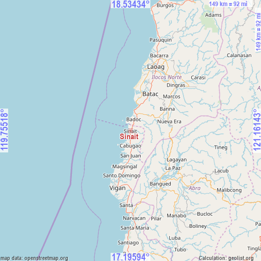
Sinait GPS coordinates[2]
17° 51' 59.04" North, 120° 27' 29.88" East
| Map corner | latitude | longitude |
|---|---|---|
| Upper-left | 18.53434°, | 119.75518° |
| Center: | 17.8664°, | 120.4583° |
| Lower-right: | 17.19594°, | 121.16143° |
| Map W x H: | 148.8×148.8 km | = 92.5×92.5mi |
| max Lat: | 20.78733° ⇑2.1% North |
| Sinait: | 17.8664° |
| min Lat: | ⇓97.9% South 4.65442° |
| min Long | Sinait | max Long |
| 117.04868° | 120.4583° | 126.58417° |
| W 8.1%⇐ | ⇒91.9% E |
Elevation
Elevation of Sinait is 13 m = 43 ft, and this is 74.9 m = 246 ft below average elevation for this country.
| Max E: |
2262 m = 7421 ft | 67.4% |
| Avg. | 87.9 m = 288 ft | |
| Sinait | 13 m = 43 ft | |
Min E: |
-2 m = -7 ft | 32.6% |
See also: Philippines elevation on elevation.city.
Geographical zone
Sinait is located in North Torrid zone (between Equator and Tropic of Cancer). Distance of this Northern Tropic circle is 619.4 km =384.9 mi to North.| Distance of | km | miles | from Sinait |
|---|---|---|---|
| North Pole | 8020.5 | 4983.7 | to North |
| Arctic Circle | 5414.6 | 3364.5 | to North |
| Tropic Cancer | 619.4 | 384.9 | to North |
| Equator | 1986.6 | 1234.4 | to South |


Nearby cities:
15 places around Sinait: (largest is in red/bold)
• Badoc
7 km =4.3 mi,  15°
15°
• Batac City
23.8 km =14.8 mi,  28°
28°
• Cabugao
8.2 km =5.1 mi,  180°
180°
• Callaguip
23 km =14.3 mi,  7°
7°
• Currimao
17.2 km =10.7 mi, 10°
• Mabusag
7.8 km =4.8 mi, 32°
• Magsingal
20.5 km =12.7 mi,  190°
190°
• Nueva Era
22.5 km =14 mi,  75°
75°
• Pagsanahan Norte
6 km =3.7 mi,  347°
347°
• Paoay
22.7 km =14.1 mi, 17°
• Pinili
12 km =7.5 mi,  37°
37°
• Puro Pinget
23.3 km =14.5 mi,  206°
206°
• Quiling
24.2 km =15 mi, 21°
• San Juan
13.8 km =8.6 mi, 179°
• Tabug
21 km =13 mi, 27°
Sources, notices
• [Note1] Compared only with cities in Philippines existing in our database
• [Src1] Map data: © OpenStreetMap contributors (CC-BY-SA)
• [Src2] Other city data from geonames.org with taken over terms of usage.
• [Src3] Geographical zone / Annual Mean Temperature by Robert A. Rohde @ Wikipedia
