Sigma geodata
Sigma (Western Visayas) is a seat of a third-order administrative division; located in Philippines in Asia/Manila (GMT+8) time zone. With population of 3,222 people, there are 2283 cities with bigger population in this country. Compared to other cities in Philippines, 52.3% of cities are located further ↑North; 51.9% of cities are located further →East and 62.8% of cities have higher elevation than Sigma. Note1


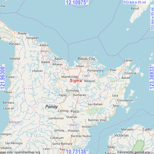
Sigma GPS coordinates[2]
11° 25' 17.04" North, 122° 39' 58.32" East
| Map corner | latitude | longitude |
|---|---|---|
| Upper-left | 12.10975°, | 121.96308° |
| Center: | 11.4214°, | 122.6662° |
| Lower-right: | 10.73138°, | 123.36933° |
| Map W x H: | 153.3×153.3 km | = 95.3×95.3mi |
| max Lat: | 20.78733° ⇑52.3% North |
| Sigma: | 11.4214° |
| min Lat: | ⇓47.7% South 4.65442° |
| min Long | Sigma | max Long |
| 117.04868° | 122.6662° | 126.58417° |
| W 48.1%⇐ | ⇒51.9% E |
Elevation
Elevation of Sigma is 15 m = 49 ft, and this is 72.9 m = 239 ft below average elevation for this country.
| Max E: |
2262 m = 7421 ft | 62.8% |
| Avg. | 87.9 m = 288 ft | |
| Sigma | 15 m = 49 ft | |
Min E: |
-2 m = -7 ft | 37.2% |
See also: Philippines elevation on elevation.city.
Geographical zone
Sigma is located in North Torrid zone (between Equator and Tropic of Cancer). Distance of Equator is 1269.9 km =789.1 mi to South.| Distance of | km | miles | from Sigma |
|---|---|---|---|
| North Pole | 8737.1 | 5429 | to North |
| Arctic Circle | 6131.2 | 3809.7 | to North |
| Tropic Cancer | 1336 | 830.2 | to North |
| Equator | 1269.9 | 789.1 | to South |


Nearby cities:
15 places around Sigma: (largest is in red/bold)
• Capaga
9.1 km =5.7 mi,  78°
78°
• Cuartero
9 km =5.6 mi,  177°
177°
• Dao
3.7 km =2.3 mi,  145°
145°
• Dapdapan
8.9 km =5.5 mi,  334°
334°
• Intampilan
10.7 km =6.6 mi,  51°
51°
• Lacaron
8.3 km =5.2 mi,  89°
89°
• Malocloc
9.5 km =5.9 mi,  8°
8°
• Mambusao
7.5 km =4.7 mi,  280°
280°
• Mangoso
3.1 km =1.9 mi,  261°
261°
• Manjoy
7.6 km =4.7 mi, 179°
• Masonogan
6 km =3.7 mi,  170°
170°
• Mianay
6.8 km =4.2 mi,  34°
34°
• Parion
6.8 km =4.2 mi, 29°
• Sapian
10.7 km =6.6 mi,  319°
319°
• Timpas
9.6 km =6 mi, 48°
Sources, notices
• [Note1] Compared only with cities in Philippines existing in our database
• [Src1] Map data: © OpenStreetMap contributors (CC-BY-SA)
• [Src2] Other city data from geonames.org with taken over terms of usage.
• [Src3] Geographical zone / Annual Mean Temperature by Robert A. Rohde @ Wikipedia
