Timpas geodata
Timpas (Western Visayas) is a populated place; located in Philippines in Asia/Manila (GMT+8) time zone. With population of 3,551 people, there are 2017 cities with bigger population in this country. Compared to other cities in Philippines, 51.6% of cities are located further ↑North; 51% of cities are located further →East and 77% of cities have lower elevation than Timpas. Note1


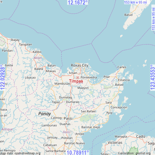
Timpas GPS coordinates[2]
11° 28' 44.4" North, 122° 43' 56.64" East
| Map corner | latitude | longitude |
|---|---|---|
| Upper-left | 12.1672°, | 122.02928° |
| Center: | 11.479°, | 122.7324° |
| Lower-right: | 10.78911°, | 123.43553° |
| Map W x H: | 153.2×153.2 km | = 95.2×95.2mi |
| max Lat: | 20.78733° ⇑51.6% North |
| Timpas: | 11.479° |
| min Lat: | ⇓48.4% South 4.65442° |
| min Long | Timpas | max Long |
| 117.04868° | 122.7324° | 126.58417° |
| W 49%⇐ | ⇒51% E |
Elevation
Elevation of Timpas is 75 m = 246 ft, and this is 12.9 m = 42 ft below average elevation for this country.
| Max E: |
2262 m = 7421 ft | 23% |
| Avg. | 87.9 m = 288 ft | |
| Timpas | 75 m = 246 ft | |
Min E: |
-2 m = -7 ft | 77% |
See also: Philippines elevation on elevation.city.
Geographical zone
Timpas is located in North Torrid zone (between Equator and Tropic of Cancer). Distance of Equator is 1276.3 km =793.1 mi to South.| Distance of | km | miles | from Timpas |
|---|---|---|---|
| North Pole | 8730.7 | 5425 | to North |
| Arctic Circle | 6124.8 | 3805.8 | to North |
| Tropic Cancer | 1329.6 | 826.2 | to North |
| Equator | 1276.3 | 793.1 | to South |


Nearby cities:
15 places around Timpas: (largest is in red/bold)
• Bolo
7.3 km =4.5 mi,  21°
21°
• Capaga
4.9 km =3 mi,  159°
159°
• Cogon
7.9 km =4.9 mi,  102°
102°
• Intampilan
1.2 km =0.7 mi,  77°
77°
• Ivisan
6.6 km =4.1 mi,  316°
316°
• Lacaron
6.4 km =4 mi,  170°
170°
• Lanot
5.2 km =3.2 mi,  31°
31°
• Lono
3.9 km =2.4 mi,  355°
355°
• Malocloc
6.6 km =4.1 mi,  296°
296°
• Mianay
3.5 km =2.2 mi,  256°
256°
• Panitan
4.6 km =2.9 mi,  108°
108°
• Parion
3.9 km =2.4 mi, 263°
• Sibaguan
9 km =5.6 mi,  347°
347°
• Sigma
9.6 km =6 mi,  228°
228°
• Tabuc Pontevedra
9.2 km =5.7 mi,  86°
86°
Sources, notices
• [Note1] Compared only with cities in Philippines existing in our database
• [Src1] Map data: © OpenStreetMap contributors (CC-BY-SA)
• [Src2] Other city data from geonames.org with taken over terms of usage.
• [Src3] Geographical zone / Annual Mean Temperature by Robert A. Rohde @ Wikipedia
