Semut geodata
Semut (Autonomous Region in Muslim Mindanao) is a populated place; located in Philippines in Asia/Manila (GMT+8) time zone. With population of 3,423 people, there are 2119 cities with bigger population in this country. Compared to other cities in Philippines, 94.4% of cities are located further ↑North; 57.9% of cities are located further →East and 85.4% of cities have higher elevation than Semut. Note1
Administrative division(s):
- Level 1: Autonomous Region in Muslim Mindanao
- Level 2: Province of Basilan
- Level 3: Hadji Mohammad Ajul


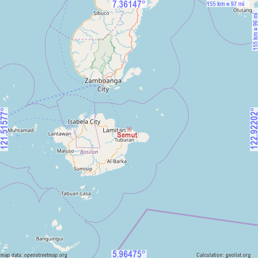
Semut GPS coordinates[2]
6° 39' 48.996" North, 122° 13' 8.004" East
| Map corner | latitude | longitude |
|---|---|---|
| Upper-left | 7.36147°, | 121.51577° |
| Center: | 6.66361°, | 122.21889° |
| Lower-right: | 5.96475°, | 122.92202° |
| Map W x H: | 155.3×155.3 km | = 96.5×96.5mi |
| max Lat: | 20.78733° ⇑94.4% North |
| Semut: | 6.66361° |
| min Lat: | ⇓5.6% South 4.65442° |
| min Long | Semut | max Long |
| 117.04868° | 122.21889° | 126.58417° |
| W 42.1%⇐ | ⇒57.9% E |
Elevation
Elevation of Semut is 8 m = 26 ft, and this is 79.9 m = 262 ft below average elevation for this country.
| Max E: |
2262 m = 7421 ft | 85.4% |
| Avg. | 87.9 m = 288 ft | |
| Semut | 8 m = 26 ft | |
Min E: |
-2 m = -7 ft | 14.6% |
See also: Philippines elevation on elevation.city.
Geographical zone
Semut is located in North Torrid zone (between Equator and Tropic of Cancer). Distance of Equator is 740.9 km =460.4 mi to South.| Distance of | km | miles | from Semut |
|---|---|---|---|
| North Pole | 9266.1 | 5757.7 | to North |
| Arctic Circle | 6660.3 | 4138.5 | to North |
| Tropic Cancer | 1865 | 1158.9 | to North |
| Equator | 740.9 | 460.4 | to South |


Nearby cities:
15 places around Semut: (largest is in red/bold)
• Balas
9.3 km =5.8 mi,  286°
286°
• Begang
22.5 km =14 mi,  277°
277°
• City of Isabela
27.7 km =17.2 mi, 279°
• Colonia
7.1 km =4.4 mi,  251°
251°
• Lamitan City
10 km =6.2 mi,  261°
261°
• Lumbayan
32.7 km =20.3 mi,  344°
344°
• Mercedes
33.7 km =20.9 mi,  346°
346°
• Santa Clara
17.6 km =10.9 mi, 275°
• Tablas
6.2 km =3.9 mi,  231°
231°
• Talabaan
31.3 km =19.4 mi, 350°
• Taluksangay
32.5 km =20.2 mi, 353°
• Tigtabon
26.4 km =16.4 mi, 347°
• Tipo-Tipo
10.1 km =6.3 mi,  205°
205°
• Tuburan
6.4 km =4 mi,  109°
109°
• Zamboanga
31.8 km =19.8 mi,  329°
329°
Sources, notices
• [Note1] Compared only with cities in Philippines existing in our database
• [Src1] Map data: © OpenStreetMap contributors (CC-BY-SA)
• [Src2] Other city data from geonames.org with taken over terms of usage.
• [Src3] Geographical zone / Annual Mean Temperature by Robert A. Rohde @ Wikipedia
