San Antonio geodata
San Antonio (Central Luzon) is a populated place; located in Philippines in Asia/Manila (GMT+8) time zone. With population of 2,568 people, there are 3170 cities with bigger population in this country. Compared to other cities in Philippines, 79.7% of cities are located further ↓South; 85.7% of cities are located further →East and 60.9% of cities have lower elevation than San Antonio. Note1


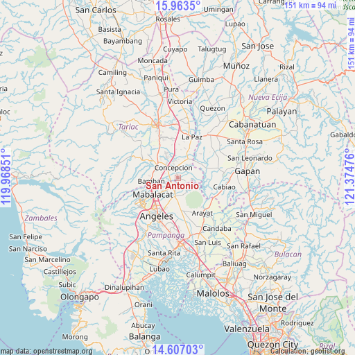
San Antonio GPS coordinates[2]
15° 17' 10.896" North, 120° 40' 17.868" East
| Map corner | latitude | longitude |
|---|---|---|
| Upper-left | 15.9635°, | 119.96851° |
| Center: | 15.28636°, | 120.67163° |
| Lower-right: | 14.60703°, | 121.37476° |
| Map W x H: | 150.8×150.8 km | = 93.7×93.7mi |
| max Lat: | 20.78733° ⇑20.3% North |
| San Antonio: | 15.28636° |
| min Lat: | ⇓79.7% South 4.65442° |
| min Long | San Antonio | max Long |
| 117.04868° | 120.67163° | 126.58417° |
| W 14.3%⇐ | ⇒85.7% E |
Elevation
Elevation of San Antonio is 35 m = 115 ft, and this is 52.9 m = 174 ft below average elevation for this country.
| Max E: |
2262 m = 7421 ft | 39.1% |
| Avg. | 87.9 m = 288 ft | |
| San Antonio | 35 m = 115 ft | |
Min E: |
-2 m = -7 ft | 60.9% |
See also: Philippines elevation on elevation.city.
Geographical zone
San Antonio is located in North Torrid zone (between Equator and Tropic of Cancer). Distance of this Northern Tropic circle is 906.2 km =563.1 mi to North.| Distance of | km | miles | from San Antonio |
|---|---|---|---|
| North Pole | 8307.4 | 5162 | to North |
| Arctic Circle | 5701.5 | 3542.7 | to North |
| Tropic Cancer | 906.2 | 563.1 | to North |
| Equator | 1699.7 | 1056.1 | to South |


Nearby cities:
15 places around San Antonio: (largest is in red/bold)
• Almendras
3.1 km =1.9 mi,  112°
112°
• Balutu
2.6 km =1.6 mi,  58°
58°
• Cafe
6.7 km =4.2 mi,  33°
33°
• Capas
10.1 km =6.3 mi,  299°
299°
• Concepcion
4.6 km =2.9 mi,  340°
340°
• Magalang
8 km =5 mi,  189°
189°
• San Isidro
6.6 km =4.1 mi,  209°
209°
• San Roque
3.5 km =2.2 mi,  217°
217°
• San Vicente
1.9 km =1.2 mi,  289°
289°
• Santa Monica
9.5 km =5.9 mi, 33°
• Santo Cristo
10.2 km =6.3 mi, 304°
• Santo Niño
7 km =4.3 mi,  141°
141°
• Santo Niño
7.2 km =4.5 mi,  317°
317°
• Tal I Mun Doc
8.4 km =5.2 mi,  170°
170°
• Tinang
10.2 km =6.3 mi,  348°
348°
Sources, notices
• [Note1] Compared only with cities in Philippines existing in our database
• [Src1] Map data: © OpenStreetMap contributors (CC-BY-SA)
• [Src2] Other city data from geonames.org with taken over terms of usage.
• [Src3] Geographical zone / Annual Mean Temperature by Robert A. Rohde @ Wikipedia
