Cafe geodata
Cafe (Central Luzon) is a populated place; located in Philippines in Asia/Manila (GMT+8) time zone. With population of 2,339 people, there are 3586 cities with bigger population in this country. Compared to other cities in Philippines, 80.2% of cities are located further ↓South; 84.8% of cities are located further →East and 51.1% of cities have lower elevation than Cafe. Note1


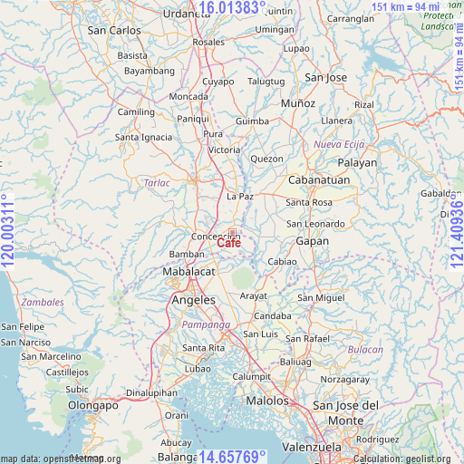
Cafe GPS coordinates[2]
15° 20' 12.696" North, 120° 42' 22.428" East
| Map corner | latitude | longitude |
|---|---|---|
| Upper-left | 16.01383°, | 120.00311° |
| Center: | 15.33686°, | 120.70623° |
| Lower-right: | 14.65769°, | 121.40936° |
| Map W x H: | 150.8×150.8 km | = 93.7×93.7mi |
| max Lat: | 20.78733° ⇑19.8% North |
| Cafe: | 15.33686° |
| min Lat: | ⇓80.2% South 4.65442° |
| min Long | Cafe | max Long |
| 117.04868° | 120.70623° | 126.58417° |
| W 15.2%⇐ | ⇒84.8% E |
Elevation
Elevation of Cafe is 24 m = 79 ft, and this is 63.9 m = 210 ft below average elevation for this country.
| Max E: |
2262 m = 7421 ft | 48.9% |
| Avg. | 87.9 m = 288 ft | |
| Cafe | 24 m = 79 ft | |
Min E: |
-2 m = -7 ft | 51.1% |
See also: Philippines elevation on elevation.city.
Geographical zone
Cafe is located in North Torrid zone (between Equator and Tropic of Cancer). Distance of this Northern Tropic circle is 900.6 km =559.6 mi to North.| Distance of | km | miles | from Cafe |
|---|---|---|---|
| North Pole | 8301.8 | 5158.5 | to North |
| Arctic Circle | 5695.9 | 3539.3 | to North |
| Tropic Cancer | 900.6 | 559.6 | to North |
| Equator | 1705.3 | 1059.6 | to South |


Nearby cities:
15 places around Cafe: (largest is in red/bold)
• Almendras
6.8 km =4.2 mi,  186°
186°
• Balutu
4.5 km =2.8 mi,  199°
199°
• Cama Juan
9.1 km =5.7 mi,  47°
47°
• Comillas
6.9 km =4.3 mi,  354°
354°
• Concepcion
5.4 km =3.4 mi,  256°
256°
• Mabilog
7.8 km =4.8 mi,  326°
326°
• Motrico
9.1 km =5.7 mi,  339°
339°
• Panabingan
7.7 km =4.8 mi, 54°
• Pando
6.8 km =4.2 mi, 340°
• San Antonio
6.7 km =4.2 mi,  213°
213°
• San Roque
10.2 km =6.3 mi, 214°
• San Vicente
7.4 km =4.6 mi,  227°
227°
• Santa Monica
2.8 km =1.7 mi,  32°
32°
• Santo Niño
8.6 km =5.3 mi,  268°
268°
• Tinang
7.2 km =4.5 mi,  307°
307°
Sources, notices
• [Note1] Compared only with cities in Philippines existing in our database
• [Src1] Map data: © OpenStreetMap contributors (CC-BY-SA)
• [Src2] Other city data from geonames.org with taken over terms of usage.
• [Src3] Geographical zone / Annual Mean Temperature by Robert A. Rohde @ Wikipedia
