Almendras geodata
Almendras (Central Luzon) is a populated place; located in Philippines in Asia/Manila (GMT+8) time zone. With population of 2,626 people, there are 3067 cities with bigger population in this country. Compared to other cities in Philippines, 79.7% of cities are located further ↓South; 85% of cities are located further →East and 55.6% of cities have lower elevation than Almendras. Note1


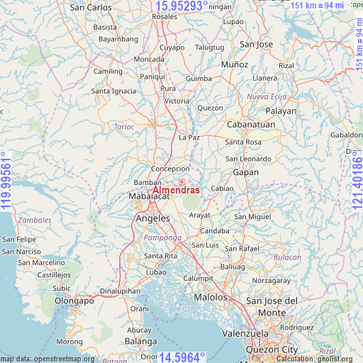
Almendras GPS coordinates[2]
15° 16' 32.736" North, 120° 41' 55.428" East
| Map corner | latitude | longitude |
|---|---|---|
| Upper-left | 15.95293°, | 119.99561° |
| Center: | 15.27576°, | 120.69873° |
| Lower-right: | 14.5964°, | 121.40186° |
| Map W x H: | 150.8×150.8 km | = 93.7×93.7mi |
| max Lat: | 20.78733° ⇑20.3% North |
| Almendras: | 15.27576° |
| min Lat: | ⇓79.7% South 4.65442° |
| min Long | Almendras | max Long |
| 117.04868° | 120.69873° | 126.58417° |
| W 15%⇐ | ⇒85% E |
Elevation
Elevation of Almendras is 28 m = 92 ft, and this is 59.9 m = 197 ft below average elevation for this country.
| Max E: |
2262 m = 7421 ft | 44.4% |
| Avg. | 87.9 m = 288 ft | |
| Almendras | 28 m = 92 ft | |
Min E: |
-2 m = -7 ft | 55.6% |
See also: Philippines elevation on elevation.city.
Geographical zone
Almendras is located in North Torrid zone (between Equator and Tropic of Cancer). Distance of this Northern Tropic circle is 907.4 km =563.8 mi to North.| Distance of | km | miles | from Almendras |
|---|---|---|---|
| North Pole | 8308.6 | 5162.7 | to North |
| Arctic Circle | 5702.7 | 3543.5 | to North |
| Tropic Cancer | 907.4 | 563.8 | to North |
| Equator | 1698.5 | 1055.4 | to South |


Nearby cities:
15 places around Almendras: (largest is in red/bold)
• Arenas
11.8 km =7.3 mi,  186°
186°
• Balutu
2.6 km =1.6 mi,  344°
344°
• Buensuseso
9.6 km =6 mi,  196°
196°
• Cafe
6.8 km =4.2 mi,  6°
6°
• Concepcion
7.1 km =4.4 mi,  321°
321°
• Magalang
7.9 km =4.9 mi,  211°
211°
• Panlinlang
10.3 km =6.4 mi,  179°
179°
• San Antonio
3.1 km =1.9 mi,  292°
292°
• San Isidro
7.6 km =4.7 mi,  233°
233°
• San Roque
5.3 km =3.3 mi,  252°
252°
• San Vicente
5 km =3.1 mi, 291°
• Santa Monica
9.4 km =5.8 mi, 14°
• Santo Niño
4.6 km =2.9 mi,  161°
161°
• Santo Niño
10.1 km =6.3 mi,  309°
309°
• Tal I Mun Doc
7.2 km =4.5 mi, 191°
Sources, notices
• [Note1] Compared only with cities in Philippines existing in our database
• [Src1] Map data: © OpenStreetMap contributors (CC-BY-SA)
• [Src2] Other city data from geonames.org with taken over terms of usage.
• [Src3] Geographical zone / Annual Mean Temperature by Robert A. Rohde @ Wikipedia
