San Agustin geodata
San Agustin (Central Visayas) is a populated place; located in Philippines in Asia/Manila (GMT+8) time zone. With population of 3,982 people, there are 1739 cities with bigger population in this country. Compared to other cities in Philippines, 72.2% of cities are located further ↑North; 67.7% of cities are located further ←West and 99.6% of cities have higher elevation than San Agustin. Note1


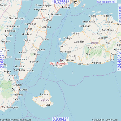
San Agustin GPS coordinates[2]
9° 37' 59.988" North, 123° 46' 59.988" East
| Map corner | latitude | longitude |
|---|---|---|
| Upper-left | 10.32581°, | 123.08021° |
| Center: | 9.63333°, | 123.78333° |
| Lower-right: | 8.93942°, | 124.48646° |
| Map W x H: | 154.2×154.2 km | = 95.8×95.8mi |
| max Lat: | 20.78733° ⇑72.2% North |
| San Agustin: | 9.63333° |
| min Lat: | ⇓27.8% South 4.65442° |
| min Long | San Agustin | max Long |
| 117.04868° | 123.78333° | 126.58417° |
| W 67.7%⇐ | ⇒32.3% E |
Elevation
Elevation of San Agustin is 1 m = 3 ft, and this is 86.9 m = 285 ft below average elevation for this country.
| Max E: |
2262 m = 7421 ft | 99.6% |
| Avg. | 87.9 m = 288 ft | |
| San Agustin | 1 m = 3 ft | |
Min E: |
-2 m = -7 ft | 0.4% |
See also: Philippines elevation on elevation.city.
Geographical zone
San Agustin is located in North Torrid zone (between Equator and Tropic of Cancer). Distance of Equator is 1071.1 km =665.6 mi to South.| Distance of | km | miles | from San Agustin |
|---|---|---|---|
| North Pole | 8935.9 | 5552.5 | to North |
| Arctic Circle | 6330 | 3933.3 | to North |
| Tropic Cancer | 1534.8 | 953.7 | to North |
| Equator | 1071.1 | 665.6 | to South |


Nearby cities:
15 places around San Agustin: (largest is in red/bold)
• Baclayon
12.2 km =7.6 mi,  93°
93°
• Biking
7.9 km =4.9 mi,  123°
123°
• Bood
13.3 km =8.3 mi,  21°
21°
• Catarman
9.2 km =5.7 mi,  112°
112°
• Danao
9.3 km =5.8 mi,  198°
198°
• Dauis
9.1 km =5.7 mi,  95°
95°
• De la Paz
11.6 km =7.2 mi,  50°
50°
• Doljo
7.7 km =4.8 mi,  228°
228°
• Panglao
7.4 km =4.6 mi,  213°
213°
• Songculan
5 km =3.1 mi, 94°
• Tabalong
3.4 km =2.1 mi, 112°
• Tagbilaran City
7.9 km =4.9 mi,  71°
71°
• Tangnan
3.1 km =1.9 mi, 200°
• Tawala
8.9 km =5.5 mi,  189°
189°
• Totolan
7 km =4.3 mi, 90°
Sources, notices
• [Note1] Compared only with cities in Philippines existing in our database
• [Src1] Map data: © OpenStreetMap contributors (CC-BY-SA)
• [Src2] Other city data from geonames.org with taken over terms of usage.
• [Src3] Geographical zone / Annual Mean Temperature by Robert A. Rohde @ Wikipedia
