Panglao geodata
Panglao (Central Visayas) is a seat of a third-order administrative division; located in Philippines in Asia/Manila (GMT+8) time zone. With population of 6,854 people, there are 908 cities with bigger population in this country. Compared to other cities in Philippines, 72.8% of cities are located further ↑North; 66.7% of cities are located further ←West and 89.7% of cities have higher elevation than Panglao. Note1


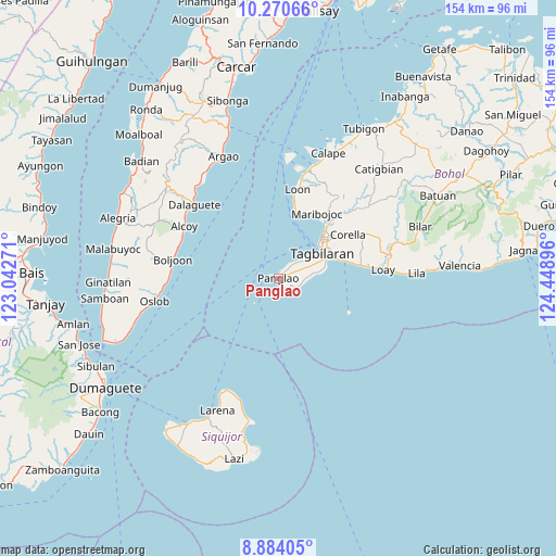
Panglao GPS coordinates[2]
9° 34' 41.016" North, 123° 44' 44.988" East
| Map corner | latitude | longitude |
|---|---|---|
| Upper-left | 10.27066°, | 123.04271° |
| Center: | 9.57806°, | 123.74583° |
| Lower-right: | 8.88405°, | 124.44896° |
| Map W x H: | 154.2×154.2 km | = 95.8×95.8mi |
| max Lat: | 20.78733° ⇑72.8% North |
| Panglao: | 9.57806° |
| min Lat: | ⇓27.2% South 4.65442° |
| min Long | Panglao | max Long |
| 117.04868° | 123.74583° | 126.58417° |
| W 66.7%⇐ | ⇒33.3% E |
Elevation
Elevation of Panglao is 7 m = 23 ft, and this is 80.9 m = 265 ft below average elevation for this country.
| Max E: |
2262 m = 7421 ft | 89.7% |
| Avg. | 87.9 m = 288 ft | |
| Panglao | 7 m = 23 ft | |
Min E: |
-2 m = -7 ft | 10.3% |
See also: Philippines elevation on elevation.city.
Geographical zone
Panglao is located in North Torrid zone (between Equator and Tropic of Cancer). Distance of Equator is 1065 km =661.8 mi to South.| Distance of | km | miles | from Panglao |
|---|---|---|---|
| North Pole | 8942.1 | 5556.4 | to North |
| Arctic Circle | 6336.2 | 3937.1 | to North |
| Tropic Cancer | 1540.9 | 957.5 | to North |
| Equator | 1065 | 661.8 | to South |


Nearby cities:
15 places around Panglao: (largest is in red/bold)
• Baclayon
17.1 km =10.6 mi,  71°
71°
• Biking
10.8 km =6.7 mi,  80°
80°
• Bood
20.6 km =12.8 mi,  25°
25°
• Catarman
12.9 km =8 mi, 78°
• Danao
2.9 km =1.8 mi,  156°
156°
• Dauis
14.2 km =8.8 mi, 68°
• De la Paz
18.8 km =11.7 mi,  43°
43°
• Doljo
2 km =1.2 mi,  301°
301°
• San Agustin
7.4 km =4.6 mi, 33°
• Songculan
10.8 km =6.7 mi,  57°
57°
• Tabalong
8.7 km =5.4 mi, 56°
• Tagbilaran City
14.5 km =9 mi,  53°
53°
• Tangnan
4.4 km =2.7 mi, 43°
• Tawala
3.7 km =2.3 mi,  135°
135°
• Totolan
12.7 km =7.9 mi, 61°
Sources, notices
• [Note1] Compared only with cities in Philippines existing in our database
• [Src1] Map data: © OpenStreetMap contributors (CC-BY-SA)
• [Src2] Other city data from geonames.org with taken over terms of usage.
• [Src3] Geographical zone / Annual Mean Temperature by Robert A. Rohde @ Wikipedia
