Totolan geodata
Totolan (Central Visayas) is a populated place; located in Philippines in Asia/Manila (GMT+8) time zone. With population of 4,030 people, there are 1712 cities with bigger population in this country. Compared to other cities in Philippines, 72.2% of cities are located further ↑North; 68.6% of cities are located further ←West and 62.9% of cities have lower elevation than Totolan. Note1


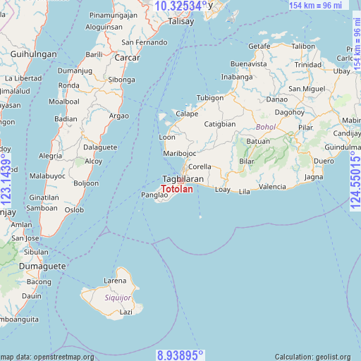
Totolan GPS coordinates[2]
9° 37' 58.296" North, 123° 50' 49.272" East
| Map corner | latitude | longitude |
|---|---|---|
| Upper-left | 10.32534°, | 123.1439° |
| Center: | 9.63286°, | 123.84702° |
| Lower-right: | 8.93895°, | 124.55015° |
| Map W x H: | 154.2×154.2 km | = 95.8×95.8mi |
| max Lat: | 20.78733° ⇑72.2% North |
| Totolan: | 9.63286° |
| min Lat: | ⇓27.8% South 4.65442° |
| min Long | Totolan | max Long |
| 117.04868° | 123.84702° | 126.58417° |
| W 68.6%⇐ | ⇒31.4% E |
Elevation
Elevation of Totolan is 38 m = 125 ft, and this is 49.9 m = 164 ft below average elevation for this country.
| Max E: |
2262 m = 7421 ft | 37.1% |
| Avg. | 87.9 m = 288 ft | |
| Totolan | 38 m = 125 ft | |
Min E: |
-2 m = -7 ft | 62.9% |
See also: Philippines elevation on elevation.city.
Geographical zone
Totolan is located in North Torrid zone (between Equator and Tropic of Cancer). Distance of Equator is 1071.1 km =665.6 mi to South.| Distance of | km | miles | from Totolan |
|---|---|---|---|
| North Pole | 8936 | 5552.6 | to North |
| Arctic Circle | 6330.1 | 3933.3 | to North |
| Tropic Cancer | 1534.8 | 953.7 | to North |
| Equator | 1071.1 | 665.6 | to South |


Nearby cities:
15 places around Totolan: (largest is in red/bold)
• Alburquerque
12.5 km =7.8 mi,  102°
102°
• Baclayon
5.2 km =3.2 mi, 97°
• Biking
4.4 km =2.7 mi,  185°
185°
• Catarman
3.8 km =2.4 mi,  155°
155°
• Corella
10.2 km =6.3 mi,  53°
53°
• Cortes
10.6 km =6.6 mi,  20°
20°
• Dauis
2.2 km =1.4 mi,  112°
112°
• De la Paz
7.7 km =4.8 mi,  14°
14°
• Maribojoc
12.1 km =7.5 mi,  358°
358°
• San Agustin
7 km =4.3 mi,  270°
270°
• Songculan
2 km =1.2 mi,  259°
259°
• Tabalong
4 km =2.5 mi,  251°
251°
• Tagbilaran City
2.6 km =1.6 mi, 12°
• Tangnan
8.5 km =5.3 mi, 250°
• Tawala
12.2 km =7.6 mi,  224°
224°
Sources, notices
• [Note1] Compared only with cities in Philippines existing in our database
• [Src1] Map data: © OpenStreetMap contributors (CC-BY-SA)
• [Src2] Other city data from geonames.org with taken over terms of usage.
• [Src3] Geographical zone / Annual Mean Temperature by Robert A. Rohde @ Wikipedia
