Bood geodata
Bood (Central Visayas) is a populated place; located in Philippines in Asia/Manila (GMT+8) time zone. With population of 2,320 people, there are 3634 cities with bigger population in this country. Compared to other cities in Philippines, 71.1% of cities are located further ↑North; 68.2% of cities are located further ←West and 79.5% of cities have lower elevation than Bood. Note1


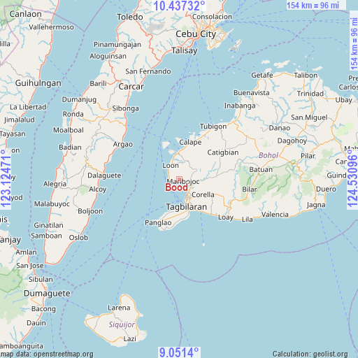
Bood GPS coordinates[2]
9° 44' 42.288" North, 123° 49' 40.188" East
| Map corner | latitude | longitude |
|---|---|---|
| Upper-left | 10.43732°, | 123.12471° |
| Center: | 9.74508°, | 123.82783° |
| Lower-right: | 9.0514°, | 124.53096° |
| Map W x H: | 154.1×154.1 km | = 95.8×95.8mi |
| max Lat: | 20.78733° ⇑71.1% North |
| Bood: | 9.74508° |
| min Lat: | ⇓28.9% South 4.65442° |
| min Long | Bood | max Long |
| 117.04868° | 123.82783° | 126.58417° |
| W 68.2%⇐ | ⇒31.8% E |
Elevation
Elevation of Bood is 89 m = 292 ft, and this is 1.1 m = 4 ft above average elevation for this country.
| Max E: |
2262 m = 7421 ft | 20.5% |
| Bood | 89 m 292 ft | |
| Avg. | 87.9 m = 288 ft | |
Min E: |
-2 m = -7 ft | 79.5% |
See also: Philippines elevation on elevation.city.
Geographical zone
Bood is located in North Torrid zone (between Equator and Tropic of Cancer). Distance of Equator is 1083.6 km =673.3 mi to South.| Distance of | km | miles | from Bood |
|---|---|---|---|
| North Pole | 8923.5 | 5544.8 | to North |
| Arctic Circle | 6317.6 | 3925.6 | to North |
| Tropic Cancer | 1522.4 | 946 | to North |
| Equator | 1083.6 | 673.3 | to South |


Nearby cities:
15 places around Bood: (largest is in red/bold)
• Antequera
8.7 km =5.4 mi,  62°
62°
• Baclayon
15.1 km =9.4 mi,  151°
151°
• Balilihan
16 km =9.9 mi,  85°
85°
• Catarman
16.4 km =10.2 mi,  167°
167°
• Corella
12.1 km =7.5 mi,  121°
121°
• Cortes
6.3 km =3.9 mi,  114°
114°
• Dauis
14 km =8.7 mi,  162°
162°
• De la Paz
6.4 km =4 mi,  141°
141°
• Loon
7.2 km =4.5 mi,  327°
327°
• Maribojoc
1.9 km =1.2 mi,  101°
101°
• San Agustin
13.3 km =8.3 mi,  201°
201°
• Songculan
12.8 km =8 mi,  179°
179°
• Tabalong
13.8 km =8.6 mi,  187°
187°
• Tagbilaran City
10.3 km =6.4 mi, 164°
• Totolan
12.7 km =7.9 mi, 170°
Sources, notices
• [Note1] Compared only with cities in Philippines existing in our database
• [Src1] Map data: © OpenStreetMap contributors (CC-BY-SA)
• [Src2] Other city data from geonames.org with taken over terms of usage.
• [Src3] Geographical zone / Annual Mean Temperature by Robert A. Rohde @ Wikipedia
