Samal geodata
Samal (Davao) is a seat of a third-order administrative division; located in Philippines in Asia/Manila (GMT+8) time zone. With population of 43,526 people, there are 197 cities with bigger population in this country. Compared to other cities in Philippines, 90.9% of cities are located further ↑North; 95.8% of cities are located further ←West and 85.4% of cities have higher elevation than Samal. Note1
Administrative division(s):
- Level 1: Davao
- Level 2: Province of Davao del Norte
- Level 3: Island Garden City of Samal


Samal GPS coordinates[2]
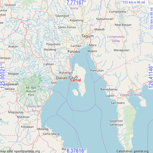
7° 4' 27.984" North, 125° 42' 29.988" East
| Map corner | latitude | longitude |
|---|---|---|
| Upper-left | 7.77167°, | 125.00521° |
| Center: | 7.07444°, | 125.70833° |
| Lower-right: | 6.37616°, | 126.41146° |
| Map W x H: | 155.2×155.2 km | = 96.4×96.4mi |
| max Lat: | 20.78733° ⇑90.9% North |
| Samal: | 7.07444° |
| min Lat: | ⇓9.1% South 4.65442° |
| min Long | Samal | max Long |
| 117.04868° | 125.70833° | 126.58417° |
| W 95.8%⇐ | ⇒4.2% E |
Elevation
Elevation of Samal is 8 m = 26 ft, and this is 79.9 m = 262 ft below average elevation for this country.
| Max E: |
2262 m = 7421 ft | 85.4% |
| Avg. | 87.9 m = 288 ft | |
| Samal | 8 m = 26 ft | |
Min E: |
-2 m = -7 ft | 14.6% |
See also: Samal elevation on elevation.city.
Geographical zone
Samal is located in North Torrid zone (between Equator and Tropic of Cancer). Distance of Equator is 786.6 km =488.8 mi to South.| Distance of | km | miles | from Samal |
|---|---|---|---|
| North Pole | 9220.5 | 5729.4 | to North |
| Arctic Circle | 6614.6 | 4110.1 | to North |
| Tropic Cancer | 1819.3 | 1130.5 | to North |
| Equator | 786.6 | 488.8 | to South |


Nearby cities:
15 places around Samal: (largest is in red/bold)
• Aumbay
8.9 km =5.5 mi,  69°
69°
• Babak
7.3 km =4.5 mi,  341°
341°
• Biao
22.9 km =14.2 mi,  295°
295°
• Camudmud
11.4 km =7.1 mi,  351°
351°
• Cogon
8.6 km =5.3 mi,  6°
6°
• Davao
10.5 km =6.5 mi,  269°
269°
• Kaputian
12.2 km =7.6 mi,  170°
170°
• Lasang
21.9 km =13.6 mi, 347°
• Limao
3.9 km =2.4 mi,  277°
277°
• Magnaga
23 km =14.3 mi,  62°
62°
• Mahayag
18.6 km =11.6 mi,  328°
328°
• Mambago
3.8 km =2.4 mi, 336°
• San Antonio
6.1 km =3.8 mi,  34°
34°
• San Remigio
18.4 km =11.4 mi,  156°
156°
• Tambo
9.2 km =5.7 mi, 353°
Sources, notices
• [Note1] Compared only with cities in Philippines existing in our database
• [Src1] Map data: © OpenStreetMap contributors (CC-BY-SA)
• [Src2] Other city data from geonames.org with taken over terms of usage.
• [Src3] Geographical zone / Annual Mean Temperature by Robert A. Rohde @ Wikipedia
