Davao geodata
Davao is a seat of a first-order administrative division; located in Philippines in Asia/Manila (GMT+8) time zone. With population of 1,212,504 people, there are 4 cities with bigger population in this country. Compared to other cities in Philippines, 91% of cities are located further ↑North; 94.6% of cities are located further ←West and 67.4% of cities have higher elevation than Davao. Note1


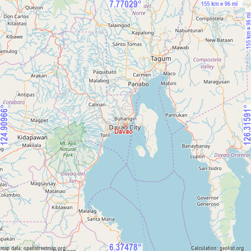
Davao GPS coordinates[2]
7° 4' 23.016" North, 125° 36' 46.008" East
| Map corner | latitude | longitude |
|---|---|---|
| Upper-left | 7.77029°, | 124.90966° |
| Center: | 7.07306°, | 125.61278° |
| Lower-right: | 6.37478°, | 126.31591° |
| Map W x H: | 155.2×155.2 km | = 96.4×96.4mi |
| max Lat: | 20.78733° ⇑91% North |
| Davao: | 7.07306° |
| min Lat: | ⇓9% South 4.65442° |
| min Long | Davao | max Long |
| 117.04868° | 125.61278° | 126.58417° |
| W 94.6%⇐ | ⇒5.4% E |
Elevation
Elevation of Davao is 13 m = 43 ft, and this is 74.9 m = 246 ft below average elevation for this country.
| Max E: |
2262 m = 7421 ft | 67.4% |
| Avg. | 87.9 m = 288 ft | |
| Davao | 13 m = 43 ft | |
Min E: |
-2 m = -7 ft | 32.6% |
See also: Davao elevation on elevation.city.
Geographical zone
Davao is located in North Torrid zone (between Equator and Tropic of Cancer). Distance of Equator is 786.5 km =488.7 mi to South.| Distance of | km | miles | from Davao |
|---|---|---|---|
| North Pole | 9220.6 | 5729.4 | to North |
| Arctic Circle | 6614.7 | 4110.2 | to North |
| Tropic Cancer | 1819.5 | 1130.6 | to North |
| Equator | 786.5 | 488.7 | to South |


Nearby cities:
15 places around Davao: (largest is in red/bold)
• Aumbay
19.1 km =11.9 mi,  80°
80°
• Babak
10.8 km =6.7 mi,  49°
49°
• Bato
15.8 km =9.8 mi,  257°
257°
• Biao
14.2 km =8.8 mi,  314°
314°
• Camudmud
14.5 km =9 mi,  37°
37°
• Cogon
14.4 km =8.9 mi, 53°
• Inawayan
19.8 km =12.3 mi,  230°
230°
• Kaputian
17.3 km =10.7 mi,  133°
133°
• Limao
6.7 km =4.2 mi, 84°
• Mahayag
16 km =9.9 mi,  2°
2°
• Mambago
9.7 km =6 mi,  68°
68°
• Samal
10.5 km =6.5 mi,  89°
89°
• San Antonio
14.9 km =9.3 mi, 69°
• Tambo
13.3 km =8.3 mi, 45°
• Ula
14.8 km =9.2 mi,  296°
296°
Sources, notices
• [Note1] Compared only with cities in Philippines existing in our database
• [Src1] Map data: © OpenStreetMap contributors (CC-BY-SA)
• [Src2] Other city data from geonames.org with taken over terms of usage.
• [Src3] Geographical zone / Annual Mean Temperature by Robert A. Rohde @ Wikipedia
