San Remigio geodata
San Remigio (Davao) is a populated place; located in Philippines in Asia/Manila (GMT+8) time zone. With population of 2,147 people, there are 3993 cities with bigger population in this country. Compared to other cities in Philippines, 92.4% of cities are located further ↑North; 96.4% of cities are located further ←West and 63.6% of cities have lower elevation than San Remigio. Note1
Administrative division(s):
- Level 1: Davao
- Level 2: Province of Davao del Norte
- Level 3: Island Garden City of Samal


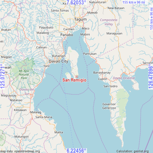
San Remigio GPS coordinates[2]
6° 55' 23.016" North, 125° 46' 32.988" East
| Map corner | latitude | longitude |
|---|---|---|
| Upper-left | 7.62053°, | 125.07271° |
| Center: | 6.92306°, | 125.77583° |
| Lower-right: | 6.22456°, | 126.47896° |
| Map W x H: | 155.2×155.2 km | = 96.4×96.4mi |
| max Lat: | 20.78733° ⇑92.4% North |
| San Remigio: | 6.92306° |
| min Lat: | ⇓7.6% South 4.65442° |
| min Long | San Remigio | max Long |
| 117.04868° | 125.77583° | 126.58417° |
| W 96.4%⇐ | ⇒3.6% E |
Elevation
Elevation of San Remigio is 39 m = 128 ft, and this is 48.9 m = 160 ft below average elevation for this country.
| Max E: |
2262 m = 7421 ft | 36.4% |
| Avg. | 87.9 m = 288 ft | |
| San Remigio | 39 m = 128 ft | |
Min E: |
-2 m = -7 ft | 63.6% |
See also: Philippines elevation on elevation.city.
Geographical zone
San Remigio is located in North Torrid zone (between Equator and Tropic of Cancer). Distance of Equator is 769.8 km =478.3 mi to South.| Distance of | km | miles | from San Remigio |
|---|---|---|---|
| North Pole | 9237.3 | 5739.8 | to North |
| Arctic Circle | 6631.4 | 4120.6 | to North |
| Tropic Cancer | 1836.1 | 1140.9 | to North |
| Equator | 769.8 | 478.3 | to South |


Nearby cities:
15 places around San Remigio: (largest is in red/bold)
• Aumbay
20 km =12.4 mi,  2°
2°
• Babak
25.6 km =15.9 mi,  337°
337°
• Banaybanay
27 km =16.8 mi,  80°
80°
• Cogon
26.1 km =16.2 mi,  345°
345°
• Davao
24.5 km =15.2 mi,  312°
312°
• Kaputian
7.3 km =4.5 mi, 310°
• Limao
20.7 km =12.9 mi,  326°
326°
• Linao
26.1 km =16.2 mi,  66°
66°
• Lupon
26 km =16.2 mi,  96°
96°
• Mambago
22.2 km =13.8 mi, 336°
• Matiao
25.1 km =15.6 mi,  44°
44°
• Samal
18.4 km =11.4 mi, 336°
• San Antonio
22.3 km =13.9 mi, 349°
• Tambo
27.3 km =17 mi, 341°
• Tombongon
25.8 km =16 mi,  47°
47°
Sources, notices
• [Note1] Compared only with cities in Philippines existing in our database
• [Src1] Map data: © OpenStreetMap contributors (CC-BY-SA)
• [Src2] Other city data from geonames.org with taken over terms of usage.
• [Src3] Geographical zone / Annual Mean Temperature by Robert A. Rohde @ Wikipedia
