Salamanca geodata
Salamanca (Western Visayas) is a populated place; located in Philippines in Asia/Manila (GMT+8) time zone. With population of 4,994 people, there are 1300 cities with bigger population in this country. Compared to other cities in Philippines, 60.2% of cities are located further ↑North; 62.8% of cities are located further ←West and 56.1% of cities have higher elevation than Salamanca. Note1
Administrative division(s):
- Level 1: Western Visayas
- Level 2: Province of Negros Occidental
- Level 3: Toboso


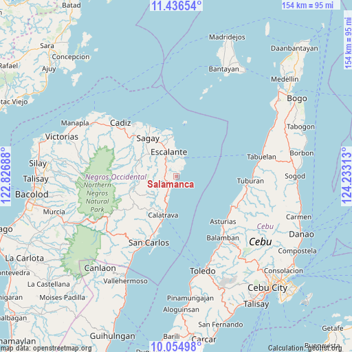
Salamanca GPS coordinates[2]
10° 44' 47.58" North, 123° 31' 48" East
| Map corner | latitude | longitude |
|---|---|---|
| Upper-left | 11.43654°, | 122.82688° |
| Center: | 10.74655°, | 123.53° |
| Lower-right: | 10.05498°, | 124.23313° |
| Map W x H: | 153.6×153.6 km | = 95.4×95.4mi |
| max Lat: | 20.78733° ⇑60.2% North |
| Salamanca: | 10.74655° |
| min Lat: | ⇓39.8% South 4.65442° |
| min Long | Salamanca | max Long |
| 117.04868° | 123.53° | 126.58417° |
| W 62.8%⇐ | ⇒37.2% E |
Elevation
Elevation of Salamanca is 19 m = 62 ft, and this is 68.9 m = 226 ft below average elevation for this country.
| Max E: |
2262 m = 7421 ft | 56.1% |
| Avg. | 87.9 m = 288 ft | |
| Salamanca | 19 m = 62 ft | |
Min E: |
-2 m = -7 ft | 43.9% |
See also: Philippines elevation on elevation.city.
Geographical zone
Salamanca is located in North Torrid zone (between Equator and Tropic of Cancer). Distance of Equator is 1194.9 km =742.5 mi to South.| Distance of | km | miles | from Salamanca |
|---|---|---|---|
| North Pole | 8812.2 | 5475.6 | to North |
| Arctic Circle | 6206.3 | 3856.4 | to North |
| Tropic Cancer | 1411 | 876.8 | to North |
| Equator | 1194.9 | 742.5 | to South |


Nearby cities:
15 places around Salamanca: (largest is in red/bold)
• Buenavista
6.4 km =4 mi,  24°
24°
• Bugang
14.9 km =9.3 mi,  267°
267°
• Calampisauan
16.3 km =10.1 mi,  201°
201°
• Cervantes
14.1 km =8.8 mi,  355°
355°
• Dian-ay
9.9 km =6.2 mi,  12°
12°
• Escalante
11 km =6.8 mi,  342°
342°
• Japitan
2.6 km =1.6 mi,  37°
37°
• Lañgub
5.7 km =3.5 mi,  4°
4°
• Libertad
10.4 km =6.5 mi, 22°
• Lopez Jaena
16.9 km =10.5 mi,  311°
311°
• Mabini
7.4 km =4.6 mi,  317°
317°
• Maquiling
15.4 km =9.6 mi,  284°
284°
• Ogtongon
3.2 km =2 mi, 339°
• Tamlang
12.1 km =7.5 mi, 316°
• Toboso
3.9 km =2.4 mi, 202°
Sources, notices
• [Note1] Compared only with cities in Philippines existing in our database
• [Src1] Map data: © OpenStreetMap contributors (CC-BY-SA)
• [Src2] Other city data from geonames.org with taken over terms of usage.
• [Src3] Geographical zone / Annual Mean Temperature by Robert A. Rohde @ Wikipedia
