Tamlang geodata
Tamlang (Western Visayas) is a populated place; located in Philippines in Asia/Manila (GMT+8) time zone. With population of 2,275 people, there are 3735 cities with bigger population in this country. Compared to other cities in Philippines, 59.1% of cities are located further ↑North; 61.3% of cities are located further ←West and 58.8% of cities have lower elevation than Tamlang. Note1
Administrative division(s):
- Level 1: Western Visayas
- Level 2: Province of Negros Occidental
- Level 3: City of Escalante


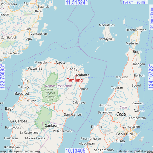
Tamlang GPS coordinates[2]
10° 49' 31.584" North, 123° 27' 14.76" East
| Map corner | latitude | longitude |
|---|---|---|
| Upper-left | 11.51524°, | 122.75098° |
| Center: | 10.82544°, | 123.4541° |
| Lower-right: | 10.13405°, | 124.15723° |
| Map W x H: | 153.6×153.6 km | = 95.4×95.4mi |
| max Lat: | 20.78733° ⇑59.1% North |
| Tamlang: | 10.82544° |
| min Lat: | ⇓40.9% South 4.65442° |
| min Long | Tamlang | max Long |
| 117.04868° | 123.4541° | 126.58417° |
| W 61.3%⇐ | ⇒38.7% E |
Elevation
Elevation of Tamlang is 32 m = 105 ft, and this is 55.9 m = 183 ft below average elevation for this country.
| Max E: |
2262 m = 7421 ft | 41.2% |
| Avg. | 87.9 m = 288 ft | |
| Tamlang | 32 m = 105 ft | |
Min E: |
-2 m = -7 ft | 58.8% |
See also: Philippines elevation on elevation.city.
Geographical zone
Tamlang is located in North Torrid zone (between Equator and Tropic of Cancer). Distance of Equator is 1203.7 km =747.9 mi to South.| Distance of | km | miles | from Tamlang |
|---|---|---|---|
| North Pole | 8803.4 | 5470.2 | to North |
| Arctic Circle | 6197.5 | 3850.9 | to North |
| Tropic Cancer | 1402.2 | 871.3 | to North |
| Equator | 1203.7 | 747.9 | to South |


Nearby cities:
15 places around Tamlang: (largest is in red/bold)
• Bato
9 km =5.6 mi,  257°
257°
• Bolanon
10.4 km =6.5 mi,  11°
11°
• Buenavista
11.3 km =7 mi,  105°
105°
• Bugang
11.4 km =7.1 mi,  215°
215°
• Cervantes
9 km =5.6 mi,  54°
54°
• Dian-ay
10.5 km =6.5 mi,  85°
85°
• Escalante
5.2 km =3.2 mi,  71°
71°
• Lañgub
9.2 km =5.7 mi, 109°
• Lopez Jaena
5 km =3.1 mi,  299°
299°
• Mabini
4.7 km =2.9 mi,  134°
134°
• Maquiling
8.2 km =5.1 mi,  233°
233°
• Ogtongon
9.2 km =5.7 mi, 128°
• Plaridel
8.9 km =5.5 mi,  25°
25°
• Rizal
7.3 km =4.5 mi,  327°
327°
• Vito
10.9 km =6.8 mi,  37°
37°
Sources, notices
• [Note1] Compared only with cities in Philippines existing in our database
• [Src1] Map data: © OpenStreetMap contributors (CC-BY-SA)
• [Src2] Other city data from geonames.org with taken over terms of usage.
• [Src3] Geographical zone / Annual Mean Temperature by Robert A. Rohde @ Wikipedia
