Roxas geodata
Roxas (Mimaropa) is a seat of a third-order administrative division; located in Philippines in Asia/Manila (GMT+8) time zone. With population of 14,335 people, there are 465 cities with bigger population in this country. Compared to other cities in Philippines, 55.5% of cities are located further ↓South; 66.2% of cities are located further →East and 80.7% of cities have higher elevation than Roxas. Note1


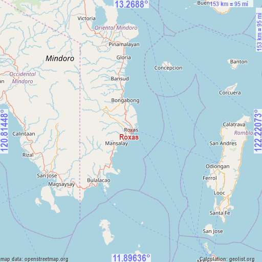
Roxas GPS coordinates[2]
12° 35' 0.6" North, 121° 31' 3.36" East
| Map corner | latitude | longitude |
|---|---|---|
| Upper-left | 13.2688°, | 120.81448° |
| Center: | 12.5835°, | 121.5176° |
| Lower-right: | 11.89636°, | 122.22073° |
| Map W x H: | 152.6×152.6 km | = 94.8×94.8mi |
| max Lat: | 20.78733° ⇑44.5% North |
| Roxas: | 12.5835° |
| min Lat: | ⇓55.5% South 4.65442° |
| min Long | Roxas | max Long |
| 117.04868° | 121.5176° | 126.58417° |
| W 33.8%⇐ | ⇒66.2% E |
Elevation
Elevation of Roxas is 9 m = 30 ft, and this is 78.9 m = 259 ft below average elevation for this country.
| Max E: |
2262 m = 7421 ft | 80.7% |
| Avg. | 87.9 m = 288 ft | |
| Roxas | 9 m = 30 ft | |
Min E: |
-2 m = -7 ft | 19.3% |
See also: Philippines elevation on elevation.city.
Geographical zone
Roxas is located in North Torrid zone (between Equator and Tropic of Cancer). Distance of this Northern Tropic circle is 1206.8 km =749.9 mi to North.| Distance of | km | miles | from Roxas |
|---|---|---|---|
| North Pole | 8607.9 | 5348.7 | to North |
| Arctic Circle | 6002 | 3729.5 | to North |
| Tropic Cancer | 1206.8 | 749.9 | to North |
| Equator | 1399.2 | 869.4 | to South |


Nearby cities:
15 places around Roxas: (largest is in red/bold)
• Anilao
14.5 km =9 mi,  357°
357°
• Balugo
8.5 km =5.3 mi,  266°
266°
• Cantel
3.8 km =2.4 mi,  353°
353°
• Cawayan
8.6 km =5.3 mi,  20°
20°
• Labasan
22.2 km =13.8 mi, 346°
• Malitbog
19.6 km =12.2 mi,  343°
343°
• Manaul
18.6 km =11.6 mi,  218°
218°
• Mansalay
11.1 km =6.9 mi,  230°
230°
• Masaguisi
20.4 km =12.7 mi, 338°
• Odiong
1.9 km =1.2 mi,  304°
304°
• Sagana
15.8 km =9.8 mi, 347°
• San Aquilino
3.7 km =2.3 mi,  294°
294°
• San Mariano
10.8 km =6.7 mi,  306°
306°
• Santa Brigida
3.6 km =2.2 mi,  240°
240°
• Santa Maria
6.2 km =3.9 mi, 265°
Sources, notices
• [Note1] Compared only with cities in Philippines existing in our database
• [Src1] Map data: © OpenStreetMap contributors (CC-BY-SA)
• [Src2] Other city data from geonames.org with taken over terms of usage.
• [Src3] Geographical zone / Annual Mean Temperature by Robert A. Rohde @ Wikipedia
