Punta geodata
Punta (Caraga) is a populated place; located in Philippines in Asia/Manila (GMT+8) time zone. With population of 3,909 people, there are 1780 cities with bigger population in this country. Compared to other cities in Philippines, 75.9% of cities are located further ↑North; 91.6% of cities are located further ←West and 98.8% of cities have higher elevation than Punta. Note1


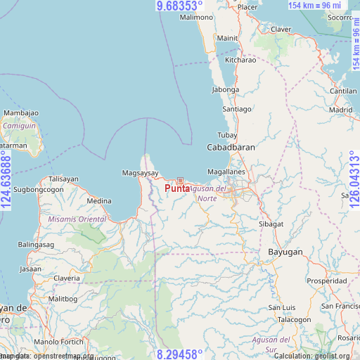
Punta GPS coordinates[2]
8° 59' 22.992" North, 125° 20' 24" East
| Map corner | latitude | longitude |
|---|---|---|
| Upper-left | 9.68353°, | 124.63688° |
| Center: | 8.98972°, | 125.34° |
| Lower-right: | 8.29458°, | 126.04313° |
| Map W x H: | 154.4×154.4 km | = 95.9×95.9mi |
| max Lat: | 20.78733° ⇑75.9% North |
| Punta: | 8.98972° |
| min Lat: | ⇓24.1% South 4.65442° |
| min Long | Punta | max Long |
| 117.04868° | 125.34° | 126.58417° |
| W 91.6%⇐ | ⇒8.4% E |
Elevation
Elevation of Punta is 2 m = 7 ft, and this is 85.9 m = 282 ft below average elevation for this country.
| Max E: |
2262 m = 7421 ft | 98.8% |
| Avg. | 87.9 m = 288 ft | |
| Punta | 2 m = 7 ft | |
Min E: |
-2 m = -7 ft | 1.2% |
See also: Philippines elevation on elevation.city.
Geographical zone
Punta is located in North Torrid zone (between Equator and Tropic of Cancer). Distance of Equator is 999.6 km =621.1 mi to South.| Distance of | km | miles | from Punta |
|---|---|---|---|
| North Pole | 9007.5 | 5597 | to North |
| Arctic Circle | 6401.6 | 3977.8 | to North |
| Tropic Cancer | 1606.4 | 998.2 | to North |
| Equator | 999.6 | 621.1 | to South |


Nearby cities:
15 places around Punta: (largest is in red/bold)
• Alubijid
9.9 km =6.2 mi,  107°
107°
• Bancasi
14.1 km =8.8 mi,  100°
100°
• Buenavista
7.7 km =4.8 mi, 100°
• Candiis
17.3 km =10.7 mi,  262°
262°
• Carmen
5.2 km =3.2 mi,  268°
268°
• Culit
5.1 km =3.2 mi,  158°
158°
• Guinabsan
13.2 km =8.2 mi,  140°
140°
• Kibonsod
14.5 km =9 mi,  277°
277°
• Kinabhangan
3 km =1.9 mi, 139°
• Magsaysay
17.6 km =10.9 mi, 281°
• Manapa
11 km =6.8 mi, 96°
• Matabao
7.5 km =4.7 mi,  118°
118°
• Nasipit
5.5 km =3.4 mi,  245°
245°
• Rizal
9.3 km =5.8 mi, 136°
• Tagcatong
9.2 km =5.7 mi, 278°
Sources, notices
• [Note1] Compared only with cities in Philippines existing in our database
• [Src1] Map data: © OpenStreetMap contributors (CC-BY-SA)
• [Src2] Other city data from geonames.org with taken over terms of usage.
• [Src3] Geographical zone / Annual Mean Temperature by Robert A. Rohde @ Wikipedia
