Alubijid geodata
Alubijid (Caraga) is a populated place; located in Philippines in Asia/Manila (GMT+8) time zone. With population of 2,700 people, there are 2944 cities with bigger population in this country. Compared to other cities in Philippines, 76.1% of cities are located further ↑North; 92.5% of cities are located further ←West and 92.7% of cities have higher elevation than Alubijid. Note1
Administrative division(s):
- Level 1: Caraga
- Level 2: Province of Agusan del Norte
- Level 3: Buenavista


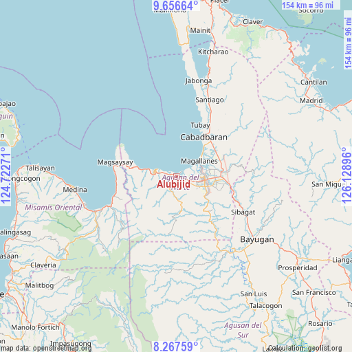
Alubijid GPS coordinates[2]
8° 57' 46.008" North, 125° 25' 32.988" East
| Map corner | latitude | longitude |
|---|---|---|
| Upper-left | 9.65664°, | 124.72271° |
| Center: | 8.96278°, | 125.42583° |
| Lower-right: | 8.26759°, | 126.12896° |
| Map W x H: | 154.4×154.5 km | = 95.9×96mi |
| max Lat: | 20.78733° ⇑76.1% North |
| Alubijid: | 8.96278° |
| min Lat: | ⇓23.9% South 4.65442° |
| min Long | Alubijid | max Long |
| 117.04868° | 125.42583° | 126.58417° |
| W 92.5%⇐ | ⇒7.5% E |
Elevation
Elevation of Alubijid is 6 m = 20 ft, and this is 81.9 m = 269 ft below average elevation for this country.
| Max E: |
2262 m = 7421 ft | 92.7% |
| Avg. | 87.9 m = 288 ft | |
| Alubijid | 6 m = 20 ft | |
Min E: |
-2 m = -7 ft | 7.3% |
See also: Philippines elevation on elevation.city.
Geographical zone
Alubijid is located in North Torrid zone (between Equator and Tropic of Cancer). Distance of Equator is 996.6 km =619.3 mi to South.| Distance of | km | miles | from Alubijid |
|---|---|---|---|
| North Pole | 9010.5 | 5598.9 | to North |
| Arctic Circle | 6404.6 | 3979.6 | to North |
| Tropic Cancer | 1609.4 | 1000 | to North |
| Equator | 996.6 | 619.3 | to South |


Nearby cities:
15 places around Alubijid: (largest is in red/bold)
• Bancasi
4.5 km =2.8 mi,  84°
84°
• Buenavista
2.4 km =1.5 mi,  310°
310°
• Butuan
13 km =8.1 mi,  96°
96°
• Caloc-an
14.8 km =9.2 mi,  50°
50°
• Culit
7.8 km =4.8 mi,  257°
257°
• Guinabsan
7.3 km =4.5 mi,  188°
188°
• Kinabhangan
7.5 km =4.7 mi,  275°
275°
• Libertad
8.6 km =5.3 mi, 103°
• Lombocan
10.1 km =6.3 mi,  60°
60°
• Magallanes
11.9 km =7.4 mi, 57°
• Manapa
2.2 km =1.4 mi,  41°
41°
• Matabao
3 km =1.9 mi, 257°
• Nasipit
14.4 km =8.9 mi,  272°
272°
• Punta
9.9 km =6.2 mi,  287°
287°
• Rizal
4.8 km =3 mi,  218°
218°
Sources, notices
• [Note1] Compared only with cities in Philippines existing in our database
• [Src1] Map data: © OpenStreetMap contributors (CC-BY-SA)
• [Src2] Other city data from geonames.org with taken over terms of usage.
• [Src3] Geographical zone / Annual Mean Temperature by Robert A. Rohde @ Wikipedia
