Rizal geodata
Rizal (Caraga) is a populated place; located in Philippines in Asia/Manila (GMT+8) time zone. With population of 2,836 people, there are 2729 cities with bigger population in this country. Compared to other cities in Philippines, 76.3% of cities are located further ↑North; 92% of cities are located further ←West and 55.6% of cities have lower elevation than Rizal. Note1
Administrative division(s):
- Level 1: Caraga
- Level 2: Province of Agusan del Norte
- Level 3: Buenavista


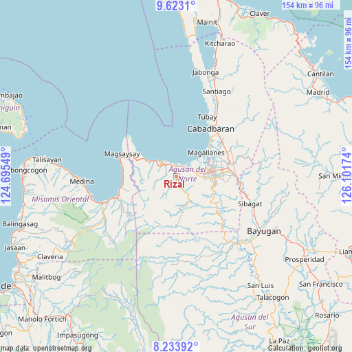
Rizal GPS coordinates[2]
8° 55' 45.012" North, 125° 23' 54.996" East
| Map corner | latitude | longitude |
|---|---|---|
| Upper-left | 9.6231°, | 124.69549° |
| Center: | 8.92917°, | 125.39861° |
| Lower-right: | 8.23392°, | 126.10174° |
| Map W x H: | 154.5×154.5 km | = 96×96mi |
| max Lat: | 20.78733° ⇑76.3% North |
| Rizal: | 8.92917° |
| min Lat: | ⇓23.7% South 4.65442° |
| min Long | Rizal | max Long |
| 117.04868° | 125.39861° | 126.58417° |
| W 92%⇐ | ⇒8% E |
Elevation
Elevation of Rizal is 28 m = 92 ft, and this is 59.9 m = 197 ft below average elevation for this country.
| Max E: |
2262 m = 7421 ft | 44.4% |
| Avg. | 87.9 m = 288 ft | |
| Rizal | 28 m = 92 ft | |
Min E: |
-2 m = -7 ft | 55.6% |
See also: Philippines elevation on elevation.city.
Geographical zone
Rizal is located in North Torrid zone (between Equator and Tropic of Cancer). Distance of Equator is 992.8 km =616.9 mi to South.| Distance of | km | miles | from Rizal |
|---|---|---|---|
| North Pole | 9014.2 | 5601.2 | to North |
| Arctic Circle | 6408.3 | 3981.9 | to North |
| Tropic Cancer | 1613.1 | 1002.3 | to North |
| Equator | 992.8 | 616.9 | to South |


Nearby cities:
15 places around Rizal: (largest is in red/bold)
• Alubijid
4.8 km =3 mi,  38°
38°
• Bancasi
8.6 km =5.3 mi,  60°
60°
• Buenavista
5.4 km =3.4 mi,  12°
12°
• Butuan
16.1 km =10 mi,  82°
82°
• Carmen
13.4 km =8.3 mi,  299°
299°
• Culit
5 km =3.1 mi,  293°
293°
• Guinabsan
4 km =2.5 mi,  151°
151°
• Kinabhangan
6.3 km =3.9 mi,  314°
314°
• Libertad
11.5 km =7.1 mi, 81°
• Lombocan
14.6 km =9.1 mi,  53°
53°
• Magallanes
16.5 km =10.3 mi, 52°
• Manapa
7 km =4.3 mi, 39°
• Matabao
3.1 km =1.9 mi,  1°
1°
• Nasipit
12.2 km =7.6 mi, 291°
• Punta
9.3 km =5.8 mi,  316°
316°
Sources, notices
• [Note1] Compared only with cities in Philippines existing in our database
• [Src1] Map data: © OpenStreetMap contributors (CC-BY-SA)
• [Src2] Other city data from geonames.org with taken over terms of usage.
• [Src3] Geographical zone / Annual Mean Temperature by Robert A. Rohde @ Wikipedia
