Kinabhangan geodata
Kinabhangan (Caraga) is a populated place; located in Philippines in Asia/Manila (GMT+8) time zone. With population of 2,626 people, there are 3067 cities with bigger population in this country. Compared to other cities in Philippines, 76.1% of cities are located further ↑North; 91.8% of cities are located further ←West and 67.4% of cities have higher elevation than Kinabhangan. Note1


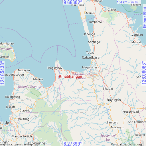
Kinabhangan GPS coordinates[2]
8° 58' 9.012" North, 125° 21' 27" East
| Map corner | latitude | longitude |
|---|---|---|
| Upper-left | 9.66302°, | 124.65438° |
| Center: | 8.96917°, | 125.3575° |
| Lower-right: | 8.27399°, | 126.06063° |
| Map W x H: | 154.4×154.4 km | = 95.9×95.9mi |
| max Lat: | 20.78733° ⇑76.1% North |
| Kinabhangan: | 8.96917° |
| min Lat: | ⇓23.9% South 4.65442° |
| min Long | Kinabhangan | max Long |
| 117.04868° | 125.3575° | 126.58417° |
| W 91.8%⇐ | ⇒8.2% E |
Elevation
Elevation of Kinabhangan is 13 m = 43 ft, and this is 74.9 m = 246 ft below average elevation for this country.
| Max E: |
2262 m = 7421 ft | 67.4% |
| Avg. | 87.9 m = 288 ft | |
| Kinabhangan | 13 m = 43 ft | |
Min E: |
-2 m = -7 ft | 32.6% |
See also: Philippines elevation on elevation.city.
Geographical zone
Kinabhangan is located in North Torrid zone (between Equator and Tropic of Cancer). Distance of Equator is 997.3 km =619.7 mi to South.| Distance of | km | miles | from Kinabhangan |
|---|---|---|---|
| North Pole | 9009.8 | 5598.4 | to North |
| Arctic Circle | 6403.9 | 3979.2 | to North |
| Tropic Cancer | 1608.6 | 999.5 | to North |
| Equator | 997.3 | 619.7 | to South |


Nearby cities:
15 places around Kinabhangan: (largest is in red/bold)
• Alubijid
7.5 km =4.7 mi,  95°
95°
• Bancasi
12 km =7.5 mi,  91°
91°
• Buenavista
5.7 km =3.5 mi,  81°
81°
• Carmen
7.5 km =4.7 mi,  286°
286°
• Culit
2.4 km =1.5 mi,  181°
181°
• Guinabsan
10.2 km =6.3 mi,  141°
141°
• Kibonsod
16.8 km =10.4 mi,  284°
284°
• Libertad
16.1 km =10 mi, 99°
• Lombocan
16.8 km =10.4 mi, 75°
• Manapa
9.1 km =5.7 mi, 83°
• Matabao
4.8 km =3 mi,  106°
106°
• Nasipit
6.9 km =4.3 mi,  270°
270°
• Punta
3 km =1.9 mi,  319°
319°
• Rizal
6.3 km =3.9 mi,  134°
134°
• Tagcatong
11.6 km =7.2 mi, 288°
Sources, notices
• [Note1] Compared only with cities in Philippines existing in our database
• [Src1] Map data: © OpenStreetMap contributors (CC-BY-SA)
• [Src2] Other city data from geonames.org with taken over terms of usage.
• [Src3] Geographical zone / Annual Mean Temperature by Robert A. Rohde @ Wikipedia
