Pualas geodata
Pualas (Northern Mindanao) is a populated place; located in Philippines in Asia/Manila (GMT+8) time zone. With population of 2,100 people, there are 4077 cities with bigger population in this country. Compared to other cities in Philippines, 82.5% of cities are located further ↑North; 68.7% of cities are located further ←West and 66.4% of cities have lower elevation than Pualas. Note1
Administrative division(s):
- Level 1: Northern Mindanao
- Level 2: Province of Lanao del Norte
- Level 3: Tubod


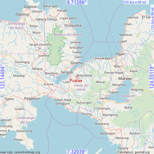
Pualas GPS coordinates[2]
8° 1' 1.992" North, 123° 50' 53.016" East
| Map corner | latitude | longitude |
|---|---|---|
| Upper-left | 8.71286°, | 123.14494° |
| Center: | 8.01722°, | 123.84806° |
| Lower-right: | 7.32039°, | 124.55119° |
| Map W x H: | 154.8×154.8 km | = 96.2×96.2mi |
| max Lat: | 20.78733° ⇑82.5% North |
| Pualas: | 8.01722° |
| min Lat: | ⇓17.5% South 4.65442° |
| min Long | Pualas | max Long |
| 117.04868° | 123.84806° | 126.58417° |
| W 68.7%⇐ | ⇒31.3% E |
Elevation
Elevation of Pualas is 44 m = 144 ft, and this is 43.9 m = 144 ft below average elevation for this country.
| Max E: |
2262 m = 7421 ft | 33.6% |
| Avg. | 87.9 m = 288 ft | |
| Pualas | 44 m = 144 ft | |
Min E: |
-2 m = -7 ft | 66.4% |
See also: Philippines elevation on elevation.city.
Geographical zone
Pualas is located in North Torrid zone (between Equator and Tropic of Cancer). Distance of Equator is 891.4 km =553.9 mi to South.| Distance of | km | miles | from Pualas |
|---|---|---|---|
| North Pole | 9115.6 | 5664.2 | to North |
| Arctic Circle | 6509.7 | 4044.9 | to North |
| Tropic Cancer | 1714.5 | 1065.3 | to North |
| Equator | 891.4 | 553.9 | to South |


Nearby cities:
15 places around Pualas: (largest is in red/bold)
• Bacolod
13.4 km =8.3 mi,  34°
34°
• Bagakay
14.7 km =9.1 mi,  345°
345°
• Baroy
7.7 km =4.8 mi,  277°
277°
• Dimaluna
12.8 km =8 mi,  335°
335°
• Kolambugan
12.1 km =7.5 mi, 26°
• Lala
12.1 km =7.5 mi,  246°
246°
• Lanipao
10.5 km =6.5 mi,  228°
228°
• Maranding
13.3 km =8.3 mi,  219°
219°
• Ozamiz City
14.6 km =9.1 mi,  356°
356°
• Panalo-on
15.5 km =9.6 mi, 224°
• Rebe
12.7 km =7.9 mi,  196°
196°
• Salvador
13.6 km =8.5 mi,  182°
182°
• Tabid
12.6 km =7.8 mi,  323°
323°
• Tangub
12.1 km =7.5 mi,  294°
294°
• Tubod
7.6 km =4.7 mi,  303°
303°
Sources, notices
• [Note1] Compared only with cities in Philippines existing in our database
• [Src1] Map data: © OpenStreetMap contributors (CC-BY-SA)
• [Src2] Other city data from geonames.org with taken over terms of usage.
• [Src3] Geographical zone / Annual Mean Temperature by Robert A. Rohde @ Wikipedia
