Lanipao geodata
Lanipao (Northern Mindanao) is a populated place; located in Philippines in Asia/Manila (GMT+8) time zone. With population of 4,114 people, there are 1660 cities with bigger population in this country. Compared to other cities in Philippines, 83.1% of cities are located further ↑North; 67.5% of cities are located further ←West and 76.6% of cities have higher elevation than Lanipao. Note1
Administrative division(s):
- Level 1: Northern Mindanao
- Level 2: Province of Lanao del Norte
- Level 3: Lala


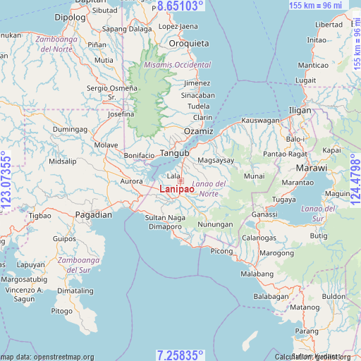
Lanipao GPS coordinates[2]
7° 57' 19.008" North, 123° 46' 36.012" East
| Map corner | latitude | longitude |
|---|---|---|
| Upper-left | 8.65103°, | 123.07355° |
| Center: | 7.95528°, | 123.77667° |
| Lower-right: | 7.25835°, | 124.4798° |
| Map W x H: | 154.9×154.9 km | = 96.3×96.3mi |
| max Lat: | 20.78733° ⇑83.1% North |
| Lanipao: | 7.95528° |
| min Lat: | ⇓16.9% South 4.65442° |
| min Long | Lanipao | max Long |
| 117.04868° | 123.77667° | 126.58417° |
| W 67.5%⇐ | ⇒32.5% E |
Elevation
Elevation of Lanipao is 10 m = 33 ft, and this is 77.9 m = 256 ft below average elevation for this country.
| Max E: |
2262 m = 7421 ft | 76.6% |
| Avg. | 87.9 m = 288 ft | |
| Lanipao | 10 m = 33 ft | |
Min E: |
-2 m = -7 ft | 23.4% |
See also: Philippines elevation on elevation.city.
Geographical zone
Lanipao is located in North Torrid zone (between Equator and Tropic of Cancer). Distance of Equator is 884.5 km =549.6 mi to South.| Distance of | km | miles | from Lanipao |
|---|---|---|---|
| North Pole | 9122.5 | 5668.5 | to North |
| Arctic Circle | 6516.6 | 4049.2 | to North |
| Tropic Cancer | 1721.4 | 1069.6 | to North |
| Equator | 884.5 | 549.6 | to South |


Nearby cities:
15 places around Lanipao: (largest is in red/bold)
• Balili
8.2 km =5.1 mi,  215°
215°
• Baroy
8 km =5 mi,  1°
1°
• Kapatagan
6.2 km =3.9 mi,  187°
187°
• Lala
3.8 km =2.4 mi,  301°
301°
• Lapining
10.4 km =6.5 mi,  249°
249°
• Maranding
3.4 km =2.1 mi, 189°
• Margos
13.2 km =8.2 mi,  258°
258°
• Panalo-on
5.2 km =3.2 mi,  214°
214°
• Pualas
10.5 km =6.5 mi,  48°
48°
• Rebe
6.8 km =4.2 mi,  141°
141°
• Salvador
9.9 km =6.2 mi,  132°
132°
• Sapad
13.3 km =8.3 mi,  151°
151°
• Sumalig
13.4 km =8.3 mi,  290°
290°
• Tangub
12.3 km =7.6 mi,  344°
344°
• Tubod
11.2 km =7 mi,  7°
7°
Sources, notices
• [Note1] Compared only with cities in Philippines existing in our database
• [Src1] Map data: © OpenStreetMap contributors (CC-BY-SA)
• [Src2] Other city data from geonames.org with taken over terms of usage.
• [Src3] Geographical zone / Annual Mean Temperature by Robert A. Rohde @ Wikipedia
