Rebe geodata
Rebe (Northern Mindanao) is a populated place; located in Philippines in Asia/Manila (GMT+8) time zone. With population of 4,413 people, there are 1534 cities with bigger population in this country. Compared to other cities in Philippines, 83.4% of cities are located further ↑North; 68.1% of cities are located further ←West and 60.3% of cities have lower elevation than Rebe. Note1
Administrative division(s):
- Level 1: Northern Mindanao
- Level 2: Province of Lanao del Norte
- Level 3: Lala


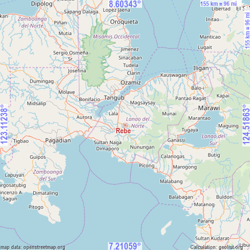
Rebe GPS coordinates[2]
7° 54' 27.36" North, 123° 48' 55.8" East
| Map corner | latitude | longitude |
|---|---|---|
| Upper-left | 8.60343°, | 123.11238° |
| Center: | 7.9076°, | 123.8155° |
| Lower-right: | 7.21059°, | 124.51863° |
| Map W x H: | 154.9×154.9 km | = 96.3×96.3mi |
| max Lat: | 20.78733° ⇑83.4% North |
| Rebe: | 7.9076° |
| min Lat: | ⇓16.6% South 4.65442° |
| min Long | Rebe | max Long |
| 117.04868° | 123.8155° | 126.58417° |
| W 68.1%⇐ | ⇒31.9% E |
Elevation
Elevation of Rebe is 34 m = 112 ft, and this is 53.9 m = 177 ft below average elevation for this country.
| Max E: |
2262 m = 7421 ft | 39.7% |
| Avg. | 87.9 m = 288 ft | |
| Rebe | 34 m = 112 ft | |
Min E: |
-2 m = -7 ft | 60.3% |
See also: Philippines elevation on elevation.city.
Geographical zone
Rebe is located in North Torrid zone (between Equator and Tropic of Cancer). Distance of Equator is 879.2 km =546.3 mi to South.| Distance of | km | miles | from Rebe |
|---|---|---|---|
| North Pole | 9127.8 | 5671.8 | to North |
| Arctic Circle | 6521.9 | 4052.5 | to North |
| Tropic Cancer | 1726.7 | 1072.9 | to North |
| Equator | 879.2 | 546.3 | to South |


Nearby cities:
15 places around Rebe: (largest is in red/bold)
• Balili
9.1 km =5.7 mi,  261°
261°
• Baroy
13.9 km =8.6 mi,  342°
342°
• Caromatan
16.7 km =10.4 mi,  221°
221°
• Kapatagan
5.2 km =3.2 mi, 260°
• Lala
10.5 km =6.5 mi,  314°
314°
• Lanipao
6.8 km =4.2 mi,  321°
321°
• Lapining
14.1 km =8.8 mi,  276°
276°
• Maranding
5.2 km =3.2 mi,  291°
291°
• Margos
17.4 km =10.8 mi, 278°
• Panalo-on
7.3 km =4.5 mi, 277°
• Pualas
12.7 km =7.9 mi,  16°
16°
• Salvador
3.4 km =2.1 mi,  113°
113°
• Sapad
6.7 km =4.2 mi,  162°
162°
• Tangub
18.7 km =11.6 mi, 336°
• Tubod
16.7 km =10.4 mi,  350°
350°
Sources, notices
• [Note1] Compared only with cities in Philippines existing in our database
• [Src1] Map data: © OpenStreetMap contributors (CC-BY-SA)
• [Src2] Other city data from geonames.org with taken over terms of usage.
• [Src3] Geographical zone / Annual Mean Temperature by Robert A. Rohde @ Wikipedia
