Pio geodata
Pio (Central Luzon) is a populated place; located in Philippines in Asia/Manila (GMT+8) time zone. With population of 24,345 people, there are 328 cities with bigger population in this country. Compared to other cities in Philippines, 78.2% of cities are located further ↓South; 90.4% of cities are located further →East and 74.6% of cities have lower elevation than Pio. Note1


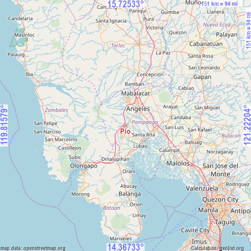
Pio GPS coordinates[2]
15° 2' 50.676" North, 120° 31' 8.076" East
| Map corner | latitude | longitude |
|---|---|---|
| Upper-left | 15.72533°, | 119.81579° |
| Center: | 15.04741°, | 120.51891° |
| Lower-right: | 14.36733°, | 121.22204° |
| Map W x H: | 151×151 km | = 93.8×93.8mi |
| max Lat: | 20.78733° ⇑21.8% North |
| Pio: | 15.04741° |
| min Lat: | ⇓78.2% South 4.65442° |
| min Long | Pio | max Long |
| 117.04868° | 120.51891° | 126.58417° |
| W 9.6%⇐ | ⇒90.4% E |
Elevation
Elevation of Pio is 67 m = 220 ft, and this is 20.9 m = 69 ft below average elevation for this country.
| Max E: |
2262 m = 7421 ft | 25.4% |
| Avg. | 87.9 m = 288 ft | |
| Pio | 67 m = 220 ft | |
Min E: |
-2 m = -7 ft | 74.6% |
See also: Philippines elevation on elevation.city.
Geographical zone
Pio is located in North Torrid zone (between Equator and Tropic of Cancer). Distance of this Northern Tropic circle is 932.8 km =579.6 mi to North.| Distance of | km | miles | from Pio |
|---|---|---|---|
| North Pole | 8333.9 | 5178.4 | to North |
| Arctic Circle | 5728.1 | 3559.3 | to North |
| Tropic Cancer | 932.8 | 579.6 | to North |
| Equator | 1673.1 | 1039.6 | to South |


Nearby cities:
15 places around Pio: (largest is in red/bold)
• Babo-Pangulo
4 km =2.5 mi,  356°
356°
• Balas
7.2 km =4.5 mi,  87°
87°
• Calantas
3.1 km =1.9 mi,  181°
181°
• Del Carmen
4.9 km =3 mi,  160°
160°
• Dolores
5.4 km =3.4 mi,  11°
11°
• Floridablanca
7.8 km =4.8 mi,  172°
172°
• Manibaug Pasig
7.3 km =4.5 mi,  42°
42°
• Maquiapo
8.1 km =5 mi,  148°
148°
• Pias
5.8 km =3.6 mi,  125°
125°
• Porac
3.6 km =2.2 mi, 43°
• Pulung Santol
4.6 km =2.9 mi, 92°
• Pulungmasle
6.7 km =4.2 mi,  141°
141°
• San Basilio
7.2 km =4.5 mi,  102°
102°
• San Roque Dau First
10 km =6.2 mi, 141°
• Santo Domingo
10 km =6.2 mi, 156°
Sources, notices
• [Note1] Compared only with cities in Philippines existing in our database
• [Src1] Map data: © OpenStreetMap contributors (CC-BY-SA)
• [Src2] Other city data from geonames.org with taken over terms of usage.
• [Src3] Geographical zone / Annual Mean Temperature by Robert A. Rohde @ Wikipedia
