Piape I geodata
Piape I (Western Visayas) is a populated place; located in Philippines in Asia/Manila (GMT+8) time zone. With population of 2,543 people, there are 3219 cities with bigger population in this country. Compared to other cities in Philippines, 60.5% of cities are located further ↑North; 60.5% of cities are located further →East and 89.7% of cities have higher elevation than Piape I. Note1


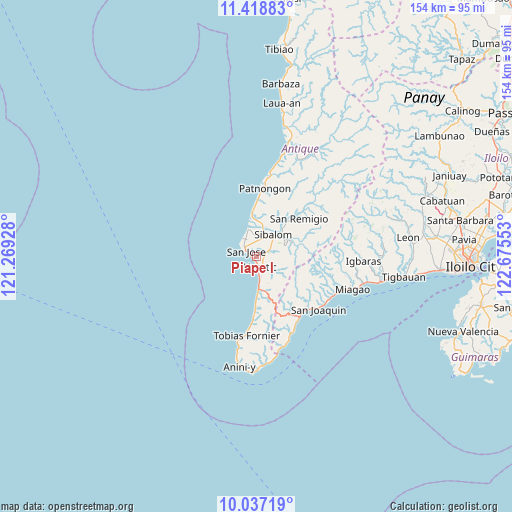
Piape I GPS coordinates[2]
10° 43' 43.68" North, 121° 58' 20.64" East
| Map corner | latitude | longitude |
|---|---|---|
| Upper-left | 11.41883°, | 121.26928° |
| Center: | 10.7288°, | 121.9724° |
| Lower-right: | 10.03719°, | 122.67553° |
| Map W x H: | 153.6×153.6 km | = 95.4×95.4mi |
| max Lat: | 20.78733° ⇑60.5% North |
| Piape I: | 10.7288° |
| min Lat: | ⇓39.5% South 4.65442° |
| min Long | Piape I | max Long |
| 117.04868° | 121.9724° | 126.58417° |
| W 39.5%⇐ | ⇒60.5% E |
Elevation
Elevation of Piape I is 7 m = 23 ft, and this is 80.9 m = 265 ft below average elevation for this country.
| Max E: |
2262 m = 7421 ft | 89.7% |
| Avg. | 87.9 m = 288 ft | |
| Piape I | 7 m = 23 ft | |
Min E: |
-2 m = -7 ft | 10.3% |
See also: Philippines elevation on elevation.city.
Geographical zone
Piape I is located in North Torrid zone (between Equator and Tropic of Cancer). Distance of Equator is 1192.9 km =741.2 mi to South.| Distance of | km | miles | from Piape I |
|---|---|---|---|
| North Pole | 8814.1 | 5476.8 | to North |
| Arctic Circle | 6208.2 | 3857.6 | to North |
| Tropic Cancer | 1413 | 878 | to North |
| Equator | 1192.9 | 741.2 | to South |


Nearby cities:
15 places around Piape I: (largest is in red/bold)
• Aurelliana
17.4 km =10.8 mi,  1°
1°
• Belison
12.3 km =7.6 mi,  353°
353°
• Catungan
6.6 km =4.1 mi,  44°
44°
• Egaña
4.6 km =2.9 mi,  63°
63°
• Hamtic
3.1 km =1.9 mi,  159°
159°
• Igbaras
32.1 km =19.9 mi,  92°
92°
• Lawigan
28.2 km =17.5 mi, 163°
• Miagao
30.2 km =18.8 mi,  108°
108°
• Patnongon
20.6 km =12.8 mi,  6°
6°
• San Joaquin
24.1 km =15 mi,  130°
130°
• San Jose
3.8 km =2.4 mi,  298°
298°
• San Pedro
8.5 km =5.3 mi,  343°
343°
• San Remigio
17.1 km =10.6 mi,  47°
47°
• Sibalom
8.4 km =5.2 mi, 36°
• Tobias Fornier
23.9 km =14.9 mi,  186°
186°
Sources, notices
• [Note1] Compared only with cities in Philippines existing in our database
• [Src1] Map data: © OpenStreetMap contributors (CC-BY-SA)
• [Src2] Other city data from geonames.org with taken over terms of usage.
• [Src3] Geographical zone / Annual Mean Temperature by Robert A. Rohde @ Wikipedia
