Aurelliana geodata
Aurelliana (Western Visayas) is a populated place; located in Philippines in Asia/Manila (GMT+8) time zone. With population of 2,172 people, there are 3945 cities with bigger population in this country. Compared to other cities in Philippines, 58.3% of cities are located further ↑North; 60.4% of cities are located further →East and 67.4% of cities have higher elevation than Aurelliana. Note1
Administrative division(s):
- Level 1: Western Visayas
- Level 2: Province of Antique
- Level 3: Patnongon


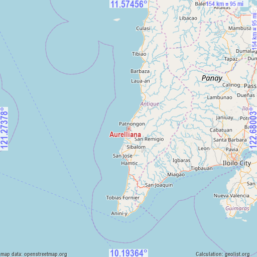
Aurelliana GPS coordinates[2]
10° 53' 5.64" North, 121° 58' 36.84" East
| Map corner | latitude | longitude |
|---|---|---|
| Upper-left | 11.57456°, | 121.27378° |
| Center: | 10.8849°, | 121.9769° |
| Lower-right: | 10.19364°, | 122.68003° |
| Map W x H: | 153.5×153.5 km | = 95.4×95.4mi |
| max Lat: | 20.78733° ⇑58.3% North |
| Aurelliana: | 10.8849° |
| min Lat: | ⇓41.7% South 4.65442° |
| min Long | Aurelliana | max Long |
| 117.04868° | 121.9769° | 126.58417° |
| W 39.6%⇐ | ⇒60.4% E |
Elevation
Elevation of Aurelliana is 13 m = 43 ft, and this is 74.9 m = 246 ft below average elevation for this country.
| Max E: |
2262 m = 7421 ft | 67.4% |
| Avg. | 87.9 m = 288 ft | |
| Aurelliana | 13 m = 43 ft | |
Min E: |
-2 m = -7 ft | 32.6% |
See also: Philippines elevation on elevation.city.
Geographical zone
Aurelliana is located in North Torrid zone (between Equator and Tropic of Cancer). Distance of Equator is 1210.3 km =752 mi to South.| Distance of | km | miles | from Aurelliana |
|---|---|---|---|
| North Pole | 8796.8 | 5466.1 | to North |
| Arctic Circle | 6190.9 | 3846.8 | to North |
| Tropic Cancer | 1395.6 | 867.2 | to North |
| Equator | 1210.3 | 752 | to South |


Nearby cities:
15 places around Aurelliana: (largest is in red/bold)
• Barbaza
35.2 km =21.9 mi,  11°
11°
• Belison
5.5 km =3.4 mi,  199°
199°
• Bugasong
20.2 km =12.6 mi,  28°
28°
• Catungan
13.4 km =8.3 mi,  161°
161°
• Egaña
15.7 km =9.8 mi,  166°
166°
• Guisijan
24.4 km =15.2 mi,  18°
18°
• Hamtic
20.3 km =12.6 mi,  178°
178°
• Igbaras
36.7 km =22.8 mi,  120°
120°
• Lawa-an
30.1 km =18.7 mi, 11°
• Patnongon
3.6 km =2.2 mi, 30°
• Piape I
17.4 km =10.8 mi, 181°
• San Jose
16 km =9.9 mi,  193°
193°
• San Pedro
9.7 km =6 mi, 197°
• San Remigio
13.4 km =8.3 mi, 115°
• Sibalom
11.5 km =7.1 mi, 157°
Sources, notices
• [Note1] Compared only with cities in Philippines existing in our database
• [Src1] Map data: © OpenStreetMap contributors (CC-BY-SA)
• [Src2] Other city data from geonames.org with taken over terms of usage.
• [Src3] Geographical zone / Annual Mean Temperature by Robert A. Rohde @ Wikipedia
