Hamtic geodata
Hamtic (Western Visayas) is a seat of a third-order administrative division; located in Philippines in Asia/Manila (GMT+8) time zone. With population of 4,816 people, there are 1367 cities with bigger population in this country. Compared to other cities in Philippines, 60.8% of cities are located further ↑North; 60.4% of cities are located further →East and 85.4% of cities have higher elevation than Hamtic. Note1


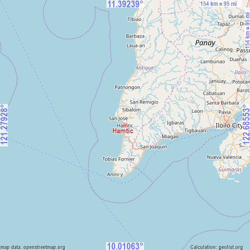
Hamtic GPS coordinates[2]
10° 42' 8.28" North, 121° 58' 56.64" East
| Map corner | latitude | longitude |
|---|---|---|
| Upper-left | 11.39239°, | 121.27928° |
| Center: | 10.7023°, | 121.9824° |
| Lower-right: | 10.01063°, | 122.68553° |
| Map W x H: | 153.6×153.6 km | = 95.4×95.4mi |
| max Lat: | 20.78733° ⇑60.8% North |
| Hamtic: | 10.7023° |
| min Lat: | ⇓39.2% South 4.65442° |
| min Long | Hamtic | max Long |
| 117.04868° | 121.9824° | 126.58417° |
| W 39.6%⇐ | ⇒60.4% E |
Elevation
Elevation of Hamtic is 8 m = 26 ft, and this is 79.9 m = 262 ft below average elevation for this country.
| Max E: |
2262 m = 7421 ft | 85.4% |
| Avg. | 87.9 m = 288 ft | |
| Hamtic | 8 m = 26 ft | |
Min E: |
-2 m = -7 ft | 14.6% |
See also: Philippines elevation on elevation.city.
Geographical zone
Hamtic is located in North Torrid zone (between Equator and Tropic of Cancer). Distance of Equator is 1190 km =739.4 mi to South.| Distance of | km | miles | from Hamtic |
|---|---|---|---|
| North Pole | 8817.1 | 5478.7 | to North |
| Arctic Circle | 6211.2 | 3859.5 | to North |
| Tropic Cancer | 1415.9 | 879.8 | to North |
| Equator | 1190 | 739.4 | to South |


Nearby cities:
15 places around Hamtic: (largest is in red/bold)
• Anini-y
30.7 km =19.1 mi,  191°
191°
• Aurelliana
20.3 km =12.6 mi,  358°
358°
• Belison
15.3 km =9.5 mi,  351°
351°
• Catungan
8.4 km =5.2 mi,  25°
25°
• Egaña
5.8 km =3.6 mi, 30°
• Lawigan
25 km =15.5 mi,  164°
164°
• Miagao
28.4 km =17.6 mi,  103°
103°
• Patnongon
23.5 km =14.6 mi,  3°
3°
• Piape I
3.1 km =1.9 mi,  339°
339°
• San Joaquin
21.4 km =13.3 mi,  126°
126°
• San Jose
6.5 km =4 mi,  316°
316°
• San Pedro
11.6 km =7.2 mi, 342°
• San Remigio
18.5 km =11.5 mi,  38°
38°
• Sibalom
10.5 km =6.5 mi,  21°
21°
• Tobias Fornier
21.2 km =13.2 mi, 190°
Sources, notices
• [Note1] Compared only with cities in Philippines existing in our database
• [Src1] Map data: © OpenStreetMap contributors (CC-BY-SA)
• [Src2] Other city data from geonames.org with taken over terms of usage.
• [Src3] Geographical zone / Annual Mean Temperature by Robert A. Rohde @ Wikipedia
