San Remigio geodata
San Remigio (Western Visayas) is a seat of a third-order administrative division; located in Philippines in Asia/Manila (GMT+8) time zone. In our database, there are 4166 cities with bigger population. Compared to other cities in Philippines, 59% of cities are located further ↑North; 59.1% of cities are located further →East and 79.1% of cities have lower elevation than San Remigio. Note1
Administrative division(s):
- Level 1: Western Visayas
- Level 2: Province of Antique
- Level 3: San Remigio


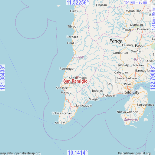
San Remigio GPS coordinates[2]
10° 49' 58.008" North, 122° 5' 15" East
| Map corner | latitude | longitude |
|---|---|---|
| Upper-left | 11.52256°, | 121.38438° |
| Center: | 10.83278°, | 122.0875° |
| Lower-right: | 10.1414°, | 122.79063° |
| Map W x H: | 153.6×153.6 km | = 95.4×95.4mi |
| max Lat: | 20.78733° ⇑59% North |
| San Remigio: | 10.83278° |
| min Lat: | ⇓41% South 4.65442° |
| min Long | San Remigio | max Long |
| 117.04868° | 122.0875° | 126.58417° |
| W 40.9%⇐ | ⇒59.1% E |
Elevation
Elevation of San Remigio is 86 m = 282 ft, and this is 1.9 m = 6 ft below average elevation for this country.
| Max E: |
2262 m = 7421 ft | 20.9% |
| Avg. | 87.9 m = 288 ft | |
| San Remigio | 86 m = 282 ft | |
Min E: |
-2 m = -7 ft | 79.1% |
See also: Philippines elevation on elevation.city.
Geographical zone
San Remigio is located in North Torrid zone (between Equator and Tropic of Cancer). Distance of Equator is 1204.5 km =748.4 mi to South.| Distance of | km | miles | from San Remigio |
|---|---|---|---|
| North Pole | 8802.6 | 5469.7 | to North |
| Arctic Circle | 6196.7 | 3850.4 | to North |
| Tropic Cancer | 1401.4 | 870.8 | to North |
| Equator | 1204.5 | 748.4 | to South |


Nearby cities:
15 places around San Remigio: (largest is in red/bold)
• Aurelliana
13.4 km =8.3 mi,  295°
295°
• Belison
13.9 km =8.6 mi,  272°
272°
• Buga
23.4 km =14.5 mi,  123°
123°
• Bugasong
23.7 km =14.7 mi,  353°
353°
• Catungan
10.5 km =6.5 mi,  228°
228°
• Egaña
12.7 km =7.9 mi,  221°
221°
• Hamtic
18.5 km =11.5 mi, 218°
• Igbaras
23.4 km =14.5 mi, 123°
• Miagao
26.5 km =16.5 mi,  142°
142°
• Patnongon
13.6 km =8.5 mi,  311°
311°
• Piape I
17.1 km =10.6 mi, 227°
• San Jose
18.7 km =11.6 mi,  238°
238°
• San Pedro
15.4 km =9.6 mi,  257°
257°
• Sibalom
9 km =5.6 mi, 238°
• Tubungan
26.3 km =16.3 mi,  106°
106°
Sources, notices
• [Note1] Compared only with cities in Philippines existing in our database
• [Src1] Map data: © OpenStreetMap contributors (CC-BY-SA)
• [Src2] Other city data from geonames.org with taken over terms of usage.
• [Src3] Geographical zone / Annual Mean Temperature by Robert A. Rohde @ Wikipedia
