Pangyan geodata
Pangyan (Soccsksargen) is a populated place; located in Philippines in Asia/Manila (GMT+8) time zone. With population of 5,261 people, there are 1214 cities with bigger population in this country. Compared to other cities in Philippines, 99.2% of cities are located further ↑North; 91% of cities are located further ←West and 99.6% of cities have higher elevation than Pangyan. Note1


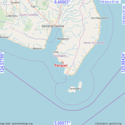
Pangyan GPS coordinates[2]
5° 42' 2.988" North, 125° 16' 51.996" East
| Map corner | latitude | longitude |
|---|---|---|
| Upper-left | 6.40003°, | 124.57799° |
| Center: | 5.70083°, | 125.28111° |
| Lower-right: | 5.00077°, | 125.98424° |
| Map W x H: | 155.6×155.6 km | = 96.7×96.7mi |
| max Lat: | 20.78733° ⇑99.2% North |
| Pangyan: | 5.70083° |
| min Lat: | ⇓0.8% South 4.65442° |
| min Long | Pangyan | max Long |
| 117.04868° | 125.28111° | 126.58417° |
| W 91%⇐ | ⇒9% E |
Elevation
Elevation of Pangyan is 1 m = 3 ft, and this is 86.9 m = 285 ft below average elevation for this country.
| Max E: |
2262 m = 7421 ft | 99.6% |
| Avg. | 87.9 m = 288 ft | |
| Pangyan | 1 m = 3 ft | |
Min E: |
-2 m = -7 ft | 0.4% |
See also: Philippines elevation on elevation.city.
Geographical zone
Pangyan is located in North Torrid zone (between Equator and Tropic of Cancer). Distance of Equator is 633.9 km =393.9 mi to South.| Distance of | km | miles | from Pangyan |
|---|---|---|---|
| North Pole | 9373.2 | 5824.2 | to North |
| Arctic Circle | 6767.3 | 4205 | to North |
| Tropic Cancer | 1972 | 1225.3 | to North |
| Equator | 633.9 | 393.9 | to South |


Nearby cities:
15 places around Pangyan: (largest is in red/bold)
• Balangonan
16.3 km =10.1 mi,  150°
150°
• Baliton
6.9 km =4.3 mi,  313°
313°
• Bukid
19.9 km =12.4 mi,  136°
136°
• Burias
3.6 km =2.2 mi,  301°
301°
• Butulan
19.2 km =11.9 mi,  119°
119°
• Glan
16.2 km =10.1 mi,  327°
327°
• Glan Peidu
18.5 km =11.5 mi,  338°
338°
• Ilaya
14.1 km =8.8 mi, 334°
• Kablalan
12.7 km =7.9 mi, 313°
• Kapatan
22.7 km =14.1 mi,  347°
347°
• Kiupo
16.2 km =10.1 mi,  15°
15°
• Nuing
18.7 km =11.6 mi,  113°
113°
• Sugal
20.4 km =12.7 mi,  102°
102°
• Taluya
17.2 km =10.7 mi,  315°
315°
• Tañgo
21.1 km =13.1 mi, 341°
Sources, notices
• [Note1] Compared only with cities in Philippines existing in our database
• [Src1] Map data: © OpenStreetMap contributors (CC-BY-SA)
• [Src2] Other city data from geonames.org with taken over terms of usage.
• [Src3] Geographical zone / Annual Mean Temperature by Robert A. Rohde @ Wikipedia
