Pangao geodata
Pangao (Calabarzon) is a populated place; located in Philippines in Asia/Manila (GMT+8) time zone. With population of 2,314 people, there are 3643 cities with bigger population in this country. Compared to other cities in Philippines, 67.8% of cities are located further ↓South; 73.1% of cities are located further →East and 92.9% of cities have lower elevation than Pangao. Note1


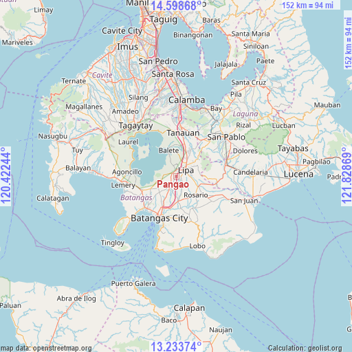
Pangao GPS coordinates[2]
13° 55' 1.992" North, 121° 7' 32.016" East
| Map corner | latitude | longitude |
|---|---|---|
| Upper-left | 14.59868°, | 120.42244° |
| Center: | 13.91722°, | 121.12556° |
| Lower-right: | 13.23374°, | 121.82869° |
| Map W x H: | 151.8×151.8 km | = 94.3×94.3mi |
| max Lat: | 20.78733° ⇑32.2% North |
| Pangao: | 13.91722° |
| min Lat: | ⇓67.8% South 4.65442° |
| min Long | Pangao | max Long |
| 117.04868° | 121.12556° | 126.58417° |
| W 26.9%⇐ | ⇒73.1% E |
Elevation
Elevation of Pangao is 324 m = 1063 ft, and this is 236.1 m = 775 ft above average elevation for this country.
| Max E: |
2262 m = 7421 ft | 7.1% |
| Pangao | 324 m 1063 ft | |
| Avg. | 87.9 m = 288 ft | |
Min E: |
-2 m = -7 ft | 92.9% |
See also: Philippines elevation on elevation.city.
Geographical zone
Pangao is located in North Torrid zone (between Equator and Tropic of Cancer). Distance of this Northern Tropic circle is 1058.5 km =657.7 mi to North.| Distance of | km | miles | from Pangao |
|---|---|---|---|
| North Pole | 8459.6 | 5256.6 | to North |
| Arctic Circle | 5853.7 | 3637.3 | to North |
| Tropic Cancer | 1058.5 | 657.7 | to North |
| Equator | 1547.4 | 961.5 | to South |


Nearby cities:
15 places around Pangao: (largest is in red/bold)
• Aya
2.8 km =1.7 mi,  206°
206°
• Balagtasin
4.3 km =2.7 mi,  246°
246°
• Banaybanay
2.1 km =1.3 mi,  327°
327°
• Bulacnin
8.3 km =5.2 mi,  10°
10°
• Cuenca
8.1 km =5 mi,  257°
257°
• Lipa City
4.8 km =3 mi,  56°
56°
• Mahabang Parang
8.6 km =5.3 mi, 328°
• Malabanan
9.2 km =5.7 mi, 5°
• Mataas Na Kahoy
4.8 km =3 mi,  344°
344°
• Rizal
5.8 km =3.6 mi,  141°
141°
• San Jose
4.9 km =3 mi, 207°
• Santa Cruz
9 km =5.6 mi,  130°
130°
• Santo Niño
7.6 km =4.7 mi,  174°
174°
• Talaibon
9 km =5.6 mi, 170°
• Taysan
6.1 km =3.8 mi, 210°
Sources, notices
• [Note1] Compared only with cities in Philippines existing in our database
• [Src1] Map data: © OpenStreetMap contributors (CC-BY-SA)
• [Src2] Other city data from geonames.org with taken over terms of usage.
• [Src3] Geographical zone / Annual Mean Temperature by Robert A. Rohde @ Wikipedia
