San Jose geodata
San Jose (Calabarzon) is a seat of a third-order administrative division; located in Philippines in Asia/Manila (GMT+8) time zone. In our database, there are 4166 cities with bigger population. Compared to other cities in Philippines, 67.1% of cities are located further ↓South; 73.7% of cities are located further →East and 90.5% of cities have lower elevation than San Jose. Note1


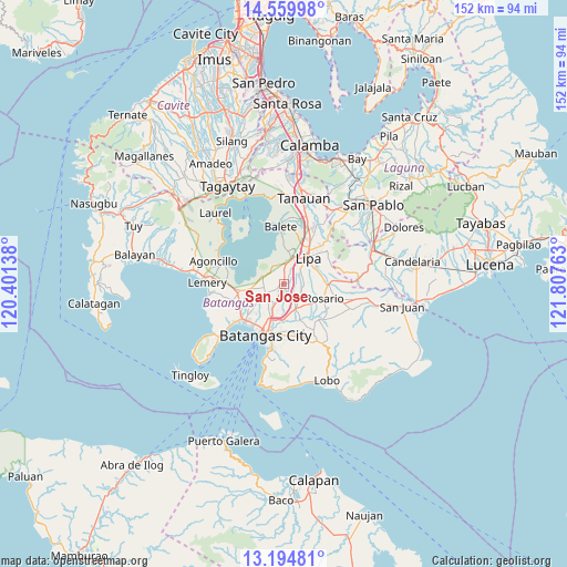
San Jose GPS coordinates[2]
13° 52' 42.24" North, 121° 6' 16.2" East
| Map corner | latitude | longitude |
|---|---|---|
| Upper-left | 14.55998°, | 120.40138° |
| Center: | 13.8784°, | 121.1045° |
| Lower-right: | 13.19481°, | 121.80763° |
| Map W x H: | 151.8×151.8 km | = 94.3×94.3mi |
| max Lat: | 20.78733° ⇑32.9% North |
| San Jose: | 13.8784° |
| min Lat: | ⇓67.1% South 4.65442° |
| min Long | San Jose | max Long |
| 117.04868° | 121.1045° | 126.58417° |
| W 26.3%⇐ | ⇒73.7% E |
Elevation
Elevation of San Jose is 238 m = 781 ft, and this is 150.1 m = 492 ft above average elevation for this country.
| Max E: |
2262 m = 7421 ft | 9.5% |
| San Jose | 238 m 781 ft | |
| Avg. | 87.9 m = 288 ft | |
Min E: |
-2 m = -7 ft | 90.5% |
See also: Philippines elevation on elevation.city.
Geographical zone
San Jose is located in North Torrid zone (between Equator and Tropic of Cancer). Distance of this Northern Tropic circle is 1062.8 km =660.4 mi to North.| Distance of | km | miles | from San Jose |
|---|---|---|---|
| North Pole | 8463.9 | 5259.2 | to North |
| Arctic Circle | 5858 | 3640 | to North |
| Tropic Cancer | 1062.8 | 660.4 | to North |
| Equator | 1543.1 | 958.8 | to South |


Nearby cities:
15 places around San Jose: (largest is in red/bold)
• Aya
2.1 km =1.3 mi,  29°
29°
• Balagtasin
3.1 km =1.9 mi,  327°
327°
• Banaybanay
6.2 km =3.9 mi,  10°
10°
• Bukal
4.8 km =3 mi,  193°
193°
• Cuenca
6.2 km =3.9 mi,  294°
294°
• Ibaan
7.4 km =4.6 mi,  155°
155°
• Lapolapo
6.1 km =3.8 mi,  143°
143°
• Mataas Na Kahoy
9 km =5.6 mi, 6°
• Matala
7.8 km =4.8 mi, 135°
• Pangao
4.9 km =3 mi, 27°
• Rizal
5.9 km =3.7 mi,  92°
92°
• Santa Cruz
9.2 km =5.7 mi,  99°
99°
• Santo Niño
4.5 km =2.8 mi, 137°
• Talaibon
5.9 km =3.7 mi, 139°
• Taysan
1.3 km =0.8 mi,  219°
219°
Sources, notices
• [Note1] Compared only with cities in Philippines existing in our database
• [Src1] Map data: © OpenStreetMap contributors (CC-BY-SA)
• [Src2] Other city data from geonames.org with taken over terms of usage.
• [Src3] Geographical zone / Annual Mean Temperature by Robert A. Rohde @ Wikipedia
