Natubleng geodata
Natubleng (Cordillera) is a populated place; located in Philippines in Asia/Manila (GMT+8) time zone. With population of 2,145 people, there are 3999 cities with bigger population in this country. Compared to other cities in Philippines, 91.8% of cities are located further ↓South; 82.8% of cities are located further →East and 100% of cities have lower elevation than Natubleng. Note1


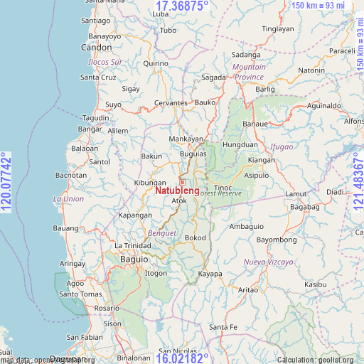
Natubleng GPS coordinates[2]
16° 41' 47.292" North, 120° 46' 49.944" East
| Map corner | latitude | longitude |
|---|---|---|
| Upper-left | 17.36875°, | 120.07742° |
| Center: | 16.69647°, | 120.78054° |
| Lower-right: | 16.02182°, | 121.48367° |
| Map W x H: | 149.8×149.8 km | = 93.1×93.1mi |
| max Lat: | 20.78733° ⇑8.2% North |
| Natubleng: | 16.69647° |
| min Lat: | ⇓91.8% South 4.65442° |
| min Long | Natubleng | max Long |
| 117.04868° | 120.78054° | 126.58417° |
| W 17.2%⇐ | ⇒82.8% E |
Elevation
Elevation of Natubleng is 2262 m = 7421 ft, and this is 2174.1 m = 7133 ft above average elevation for this country.
| Max E: |
2262 m = 7421 ft | 0% |
| Natubleng | 2262 m 7421 ft | |
| Avg. | 87.9 m = 288 ft | |
Min E: |
-2 m = -7 ft | 100% |
See also: Philippines elevation on elevation.city.
Geographical zone
Natubleng is located in North Torrid zone (between Equator and Tropic of Cancer). Distance of this Northern Tropic circle is 749.4 km =465.7 mi to North.| Distance of | km | miles | from Natubleng |
|---|---|---|---|
| North Pole | 8150.6 | 5064.5 | to North |
| Arctic Circle | 5544.7 | 3445.3 | to North |
| Tropic Cancer | 749.4 | 465.7 | to North |
| Equator | 1856.5 | 1153.6 | to South |


Nearby cities:
15 places around Natubleng: (largest is in red/bold)
• Amlimay
6 km =3.7 mi,  92°
92°
• Ampusungan
11.1 km =6.9 mi,  327°
327°
• Atok
15.2 km =9.4 mi,  214°
214°
• Baculongan
12.8 km =8 mi,  26°
26°
• Bakun
16.2 km =10.1 mi,  309°
309°
• Bangao
15.3 km =9.5 mi,  24°
24°
• Buguias
5.9 km =3.7 mi,  60°
60°
• Bulalacao
15.8 km =9.8 mi,  10°
10°
• Dalipey
13.4 km =8.3 mi, 329°
• Gambang
6 km =3.7 mi,  2°
2°
• Kabayan
10.3 km =6.4 mi,  141°
141°
• Kibungan
13.3 km =8.3 mi,  269°
269°
• Tabio
17.2 km =10.7 mi, 6°
• Tacadang
15.3 km =9.5 mi,  282°
282°
• Topdac
17.3 km =10.7 mi, 205°
Sources, notices
• [Note1] Compared only with cities in Philippines existing in our database
• [Src1] Map data: © OpenStreetMap contributors (CC-BY-SA)
• [Src2] Other city data from geonames.org with taken over terms of usage.
• [Src3] Geographical zone / Annual Mean Temperature by Robert A. Rohde @ Wikipedia
