Tacadang geodata
Tacadang (Cordillera) is a populated place; located in Philippines in Asia/Manila (GMT+8) time zone. With population of 2,402 people, there are 3457 cities with bigger population in this country. Compared to other cities in Philippines, 92% of cities are located further ↓South; 86.9% of cities are located further →East and 99.7% of cities have lower elevation than Tacadang. Note1


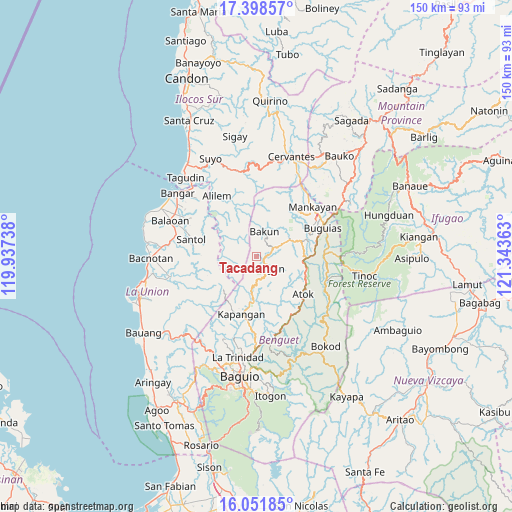
Tacadang GPS coordinates[2]
16° 43' 35.04" North, 120° 38' 25.8" East
| Map corner | latitude | longitude |
|---|---|---|
| Upper-left | 17.39857°, | 119.93738° |
| Center: | 16.7264°, | 120.6405° |
| Lower-right: | 16.05185°, | 121.34363° |
| Map W x H: | 149.7×149.7 km | = 93×93mi |
| max Lat: | 20.78733° ⇑8% North |
| Tacadang: | 16.7264° |
| min Lat: | ⇓92% South 4.65442° |
| min Long | Tacadang | max Long |
| 117.04868° | 120.6405° | 126.58417° |
| W 13.1%⇐ | ⇒86.9% E |
Elevation
Elevation of Tacadang is 1454 m = 4770 ft, and this is 1366.1 m = 4482 ft above average elevation for this country.
| Max E: |
2262 m = 7421 ft | 0.3% |
| Tacadang | 1454 m 4770 ft | |
| Avg. | 87.9 m = 288 ft | |
Min E: |
-2 m = -7 ft | 99.7% |
See also: Philippines elevation on elevation.city.
Geographical zone
Tacadang is located in North Torrid zone (between Equator and Tropic of Cancer). Distance of this Northern Tropic circle is 746.1 km =463.6 mi to North.| Distance of | km | miles | from Tacadang |
|---|---|---|---|
| North Pole | 8147.3 | 5062.5 | to North |
| Arctic Circle | 5541.4 | 3443.3 | to North |
| Tropic Cancer | 746.1 | 463.6 | to North |
| Equator | 1859.8 | 1155.6 | to South |


Nearby cities:
15 places around Tacadang: (largest is in red/bold)
• Amlimay
21.2 km =13.2 mi,  99°
99°
• Ampusungan
10.8 km =6.7 mi,  56°
56°
• Atok
17.1 km =10.6 mi,  158°
158°
• Bakun
7.4 km =4.6 mi,  18°
18°
• Buguias
20 km =12.4 mi,  91°
91°
• Dalipey
11.5 km =7.1 mi,  44°
44°
• Gambang
15.4 km =9.6 mi,  80°
80°
• Kapangan
17.5 km =10.9 mi,  195°
195°
• Kibungan
3.8 km =2.4 mi, 155°
• Loacan
19.8 km =12.3 mi,  171°
171°
• Natubleng
15.3 km =9.5 mi, 102°
• Santol
19.8 km =12.3 mi,  284°
284°
• Sugpon
18.6 km =11.6 mi,  314°
314°
• Topdac
20.5 km =12.7 mi, 158°
• Tublay
20.6 km =12.8 mi,  189°
189°
Sources, notices
• [Note1] Compared only with cities in Philippines existing in our database
• [Src1] Map data: © OpenStreetMap contributors (CC-BY-SA)
• [Src2] Other city data from geonames.org with taken over terms of usage.
• [Src3] Geographical zone / Annual Mean Temperature by Robert A. Rohde @ Wikipedia
