Kabayan geodata
Kabayan (Cordillera) is a seat of a third-order administrative division; located in Philippines in Asia/Manila (GMT+8) time zone. In our database, there are 4166 cities with bigger population. Compared to other cities in Philippines, 91.6% of cities are located further ↓South; 81.3% of cities are located further →East and 99.4% of cities have lower elevation than Kabayan. Note1


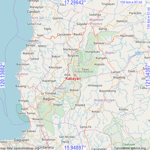
Kabayan GPS coordinates[2]
16° 37' 25.968" North, 120° 50' 23.784" East
| Map corner | latitude | longitude |
|---|---|---|
| Upper-left | 17.29642°, | 120.13682° |
| Center: | 16.62388°, | 120.83994° |
| Lower-right: | 15.94897°, | 121.54307° |
| Map W x H: | 149.8×149.8 km | = 93.1×93.1mi |
| max Lat: | 20.78733° ⇑8.4% North |
| Kabayan: | 16.62388° |
| min Lat: | ⇓91.6% South 4.65442° |
| min Long | Kabayan | max Long |
| 117.04868° | 120.83994° | 126.58417° |
| W 18.7%⇐ | ⇒81.3% E |
Elevation
Elevation of Kabayan is 1214 m = 3983 ft, and this is 1126.1 m = 3695 ft above average elevation for this country.
| Max E: |
2262 m = 7421 ft | 0.59999999999999% |
| Kabayan | 1214 m 3983 ft | |
| Avg. | 87.9 m = 288 ft | |
Min E: |
-2 m = -7 ft | 99.4% |
See also: Philippines elevation on elevation.city.
Geographical zone
Kabayan is located in North Torrid zone (between Equator and Tropic of Cancer). Distance of this Northern Tropic circle is 757.5 km =470.7 mi to North.| Distance of | km | miles | from Kabayan |
|---|---|---|---|
| North Pole | 8158.7 | 5069.6 | to North |
| Arctic Circle | 5552.8 | 3450.3 | to North |
| Tropic Cancer | 757.5 | 470.7 | to North |
| Equator | 1848.4 | 1148.5 | to South |


Nearby cities:
15 places around Kabayan: (largest is in red/bold)
• Ambuclao
18.3 km =11.4 mi,  211°
211°
• Amlimay
7.8 km =4.8 mi,  357°
357°
• Ampusungan
21.3 km =13.2 mi,  324°
324°
• Atok
15.6 km =9.7 mi,  253°
253°
• Baculongan
19.6 km =12.2 mi, 357°
• Bangao
21.9 km =13.6 mi,  0°
0°
• Bokod
15 km =9.3 mi,  183°
183°
• Buguias
11.1 km =6.9 mi,  353°
353°
• Bulalacao
23.8 km =14.8 mi, 351°
• Dalipey
23.6 km =14.7 mi,  326°
326°
• Gambang
15.3 km =9.5 mi,  336°
336°
• Kibungan
21.2 km =13.2 mi,  291°
291°
• Loacan
20.2 km =12.6 mi, 246°
• Natubleng
10.3 km =6.4 mi, 321°
• Topdac
15.7 km =9.8 mi,  240°
240°
Sources, notices
• [Note1] Compared only with cities in Philippines existing in our database
• [Src1] Map data: © OpenStreetMap contributors (CC-BY-SA)
• [Src2] Other city data from geonames.org with taken over terms of usage.
• [Src3] Geographical zone / Annual Mean Temperature by Robert A. Rohde @ Wikipedia
