Nangka geodata
Nangka (Central Visayas) is a populated place; located in Philippines in Asia/Manila (GMT+8) time zone. With population of 9,708 people, there are 633 cities with bigger population in this country. Compared to other cities in Philippines, 73.6% of cities are located further ↑North; 50.1% of cities are located further ←West and 67.4% of cities have higher elevation than Nangka. Note1
Administrative division(s):
- Level 1: Central Visayas
- Level 2: Province of Negros Oriental
- Level 3: City of Bayawan (Tulong)


Nangka GPS coordinates[2]
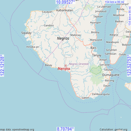
9° 24' 8.28" North, 122° 49' 27.84" East
| Map corner | latitude | longitude |
|---|---|---|
| Upper-left | 10.09527°, | 122.12128° |
| Center: | 9.4023°, | 122.8244° |
| Lower-right: | 8.70794°, | 123.52753° |
| Map W x H: | 154.3×154.3 km | = 95.9×95.9mi |
| max Lat: | 20.78733° ⇑73.6% North |
| Nangka: | 9.4023° |
| min Lat: | ⇓26.4% South 4.65442° |
| min Long | Nangka | max Long |
| 117.04868° | 122.8244° | 126.58417° |
| W 50.1%⇐ | ⇒49.9% E |
Elevation
Elevation of Nangka is 13 m = 43 ft, and this is 74.9 m = 246 ft below average elevation for this country.
| Max E: |
2262 m = 7421 ft | 67.4% |
| Avg. | 87.9 m = 288 ft | |
| Nangka | 13 m = 43 ft | |
Min E: |
-2 m = -7 ft | 32.6% |
See also: Philippines elevation on elevation.city.
Geographical zone
Nangka is located in North Torrid zone (between Equator and Tropic of Cancer). Distance of Equator is 1045.4 km =649.6 mi to South.| Distance of | km | miles | from Nangka |
|---|---|---|---|
| North Pole | 8961.6 | 5568.5 | to North |
| Arctic Circle | 6355.7 | 3949.2 | to North |
| Tropic Cancer | 1560.5 | 969.6 | to North |
| Equator | 1045.4 | 649.6 | to South |


Nearby cities:
15 places around Nangka: (largest is in red/bold)
• Alangilan
14.9 km =9.3 mi,  156°
156°
• Amio
13.8 km =8.6 mi,  111°
111°
• Apoya
22.1 km =13.7 mi, 156°
• Bal-os
22.2 km =13.8 mi,  281°
281°
• Balayong
27.3 km =17 mi,  72°
72°
• Basay
20.2 km =12.6 mi,  272°
272°
• Bayawan
4.7 km =2.9 mi,  208°
208°
• Colipapa
29.9 km =18.6 mi,  285°
285°
• Datagon
29.4 km =18.3 mi,  80°
80°
• Malabugas
7 km =4.3 mi,  238°
238°
• Manalongon
21.3 km =13.2 mi, 161°
• Maninihon
3.9 km =2.4 mi,  153°
153°
• Nagbalaye
17.9 km =11.1 mi, 161°
• Santa Catalina
8.8 km =5.5 mi, 150°
• Tabuan
12.9 km =8 mi,  12°
12°
Sources, notices
• [Note1] Compared only with cities in Philippines existing in our database
• [Src1] Map data: © OpenStreetMap contributors (CC-BY-SA)
• [Src2] Other city data from geonames.org with taken over terms of usage.
• [Src3] Geographical zone / Annual Mean Temperature by Robert A. Rohde @ Wikipedia
