Basay geodata
Basay (Central Visayas) is a seat of a third-order administrative division; located in Philippines in Asia/Manila (GMT+8) time zone. With population of 4,307 people, there are 1578 cities with bigger population in this country. Compared to other cities in Philippines, 73.6% of cities are located further ↑North; 52.3% of cities are located further →East and 73.2% of cities have higher elevation than Basay. Note1
Administrative division(s):
- Level 1: Central Visayas
- Level 2: Province of Negros Oriental
- Level 3: Basay


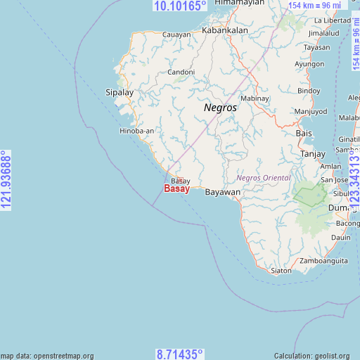
Basay GPS coordinates[2]
9° 24' 31.32" North, 122° 38' 24" East
| Map corner | latitude | longitude |
|---|---|---|
| Upper-left | 10.10165°, | 121.93688° |
| Center: | 9.4087°, | 122.64° |
| Lower-right: | 8.71435°, | 123.34313° |
| Map W x H: | 154.3×154.3 km | = 95.9×95.9mi |
| max Lat: | 20.78733° ⇑73.6% North |
| Basay: | 9.4087° |
| min Lat: | ⇓26.4% South 4.65442° |
| min Long | Basay | max Long |
| 117.04868° | 122.64° | 126.58417° |
| W 47.7%⇐ | ⇒52.3% E |
Elevation
Elevation of Basay is 11 m = 36 ft, and this is 76.9 m = 252 ft below average elevation for this country.
| Max E: |
2262 m = 7421 ft | 73.2% |
| Avg. | 87.9 m = 288 ft | |
| Basay | 11 m = 36 ft | |
Min E: |
-2 m = -7 ft | 26.8% |
See also: Philippines elevation on elevation.city.
Geographical zone
Basay is located in North Torrid zone (between Equator and Tropic of Cancer). Distance of Equator is 1046.1 km =650 mi to South.| Distance of | km | miles | from Basay |
|---|---|---|---|
| North Pole | 8960.9 | 5568 | to North |
| Arctic Circle | 6355 | 3948.8 | to North |
| Tropic Cancer | 1559.8 | 969.2 | to North |
| Equator | 1046.1 | 650 | to South |


Nearby cities:
15 places around Basay: (largest is in red/bold)
• Alangilan
29.9 km =18.6 mi,  118°
118°
• Alim
24.1 km =15 mi,  316°
316°
• Amio
33.5 km =20.8 mi,  99°
99°
• Asia
20.8 km =12.9 mi, 319°
• Bacuyangan
31.4 km =19.5 mi, 324°
• Bal-os
4 km =2.5 mi,  336°
336°
• Bayawan
18.6 km =11.6 mi,  105°
105°
• Colipapa
11.2 km =7 mi,  309°
309°
• Malabugas
14.9 km =9.3 mi, 107°
• Manalongon
34.1 km =21.2 mi,  127°
127°
• Maninihon
22.4 km =13.9 mi, 100°
• Nagbalaye
31.4 km =19.5 mi, 124°
• Nangka
20.2 km =12.6 mi,  92°
92°
• Santa Catalina
25.9 km =16.1 mi, 108°
• Tabuan
26 km =16.2 mi,  62°
62°
Sources, notices
• [Note1] Compared only with cities in Philippines existing in our database
• [Src1] Map data: © OpenStreetMap contributors (CC-BY-SA)
• [Src2] Other city data from geonames.org with taken over terms of usage.
• [Src3] Geographical zone / Annual Mean Temperature by Robert A. Rohde @ Wikipedia
