Datagon geodata
Datagon (Central Visayas) is a populated place; located in Philippines in Asia/Manila (GMT+8) time zone. With population of 2,584 people, there are 3137 cities with bigger population in this country. Compared to other cities in Philippines, 73.4% of cities are located further ↑North; 54.9% of cities are located further ←West and 79.2% of cities have lower elevation than Datagon. Note1
Administrative division(s):
- Level 1: Central Visayas
- Level 2: Province of Negros Oriental
- Level 3: Pamplona


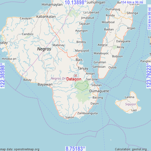
Datagon GPS coordinates[2]
9° 26' 45.96" North, 123° 5' 20.76" East
| Map corner | latitude | longitude |
|---|---|---|
| Upper-left | 10.13898°, | 122.38598° |
| Center: | 9.4461°, | 123.0891° |
| Lower-right: | 8.75183°, | 123.79223° |
| Map W x H: | 154.2×154.2 km | = 95.8×95.8mi |
| max Lat: | 20.78733° ⇑73.4% North |
| Datagon: | 9.4461° |
| min Lat: | ⇓26.6% South 4.65442° |
| min Long | Datagon | max Long |
| 117.04868° | 123.0891° | 126.58417° |
| W 54.9%⇐ | ⇒45.1% E |
Elevation
Elevation of Datagon is 87 m = 285 ft, and this is 0.90000000000001 m = 3 ft below average elevation for this country.
| Max E: |
2262 m = 7421 ft | 20.8% |
| Avg. | 87.9 m = 288 ft | |
| Datagon | 87 m = 285 ft | |
Min E: |
-2 m = -7 ft | 79.2% |
See also: Philippines elevation on elevation.city.
Geographical zone
Datagon is located in North Torrid zone (between Equator and Tropic of Cancer). Distance of Equator is 1050.3 km =652.6 mi to South.| Distance of | km | miles | from Datagon |
|---|---|---|---|
| North Pole | 8956.8 | 5565.5 | to North |
| Arctic Circle | 6350.9 | 3946.3 | to North |
| Tropic Cancer | 1555.6 | 966.6 | to North |
| Equator | 1050.3 | 652.6 | to South |


Nearby cities:
15 places around Datagon: (largest is in red/bold)
• Amio
19 km =11.8 mi,  238°
238°
• Azagra
6.3 km =3.9 mi,  55°
55°
• Bais
16.5 km =10.3 mi,  12°
12°
• Balayong
4.3 km =2.7 mi,  316°
316°
• Jantianon
8.4 km =5.2 mi,  91°
91°
• Jugno
12.8 km =8 mi,  78°
78°
• Novallas
8.2 km =5.1 mi,  26°
26°
• Okiot
15.9 km =9.9 mi, 32°
• Pamplona
4.4 km =2.7 mi,  48°
48°
• Polo
10.7 km =6.6 mi,  68°
68°
• San Jose
16.8 km =10.4 mi,  103°
103°
• Santa Cruz
10.1 km =6.3 mi, 10°
• Silab
9.9 km =6.2 mi, 95°
• Tandayag
15.5 km =9.6 mi, 86°
• Tanjay
10.9 km =6.8 mi,  44°
44°
Sources, notices
• [Note1] Compared only with cities in Philippines existing in our database
• [Src1] Map data: © OpenStreetMap contributors (CC-BY-SA)
• [Src2] Other city data from geonames.org with taken over terms of usage.
• [Src3] Geographical zone / Annual Mean Temperature by Robert A. Rohde @ Wikipedia
